|
|
|
|
|
Haston Big Spring Area - Early Settlers |
|
|
|
|

|

|

|

|

|

|

|
|
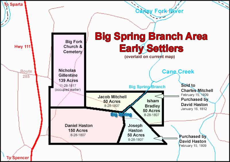
The "Haston Big Spring" Area The area south of the Caney Fork River, near the mouth of Cane Creek, was a prominent settlement in the early 1800s. It was part of White County, Tennessee prior to its inclusion into newly formed Van Buren County in 1840. The abundance of water sources in that area was probably the primary reason that many land seeking pioneers found the region so attractive. A large perpetual spring flows into Cane Creek approximately one half mile before Cane Creek itself empties into the Caney Fork River. Early documents refer to this feeder stream as "Big Spring" or "Big Spring Branch." Local residents sometimes referred to it as the "Haston Big Spring." The spring is certainly not impressive in its length. It flows out of the side of the Cumberland Mountain and meanders only a few hundred yards before spilling into Cane Creek. The volume and clarity of water produced by the large spring, however, must have been very impressive to the early settlers for whom fresh, perpetual water sources were as valuable as gold. The quality and quantity of this water source, must have made the land surrounding Big Spring the prime homestead location for miles up and down the south side of the Caney Fork. Thus, we can probably safely surmise that the families that claimed Big Spring as a focal point for their homesteads were some of the earliest settlers of that area. How did these families locate such a fortunate section of real estate? Did they simply "stumble upon it" in their land search forays? Some Haston researchers have suggested that perhaps Daniel Haston had been a "long hunter" in this area many years prior to his arrival as a homesteader. It is true that the Middle Tennessee area was a prime hunting ground for Virginia and Carolina long hunters in the pre-Revolutionary War era. But, there is no hard evidence to suggest that Daniel was a long hunter. But, it is possible though that he and his older sons made a land-scouting trip to the area while they were living in Knox County, TN, looking for a good place to settle (squat) while waiting for the land to become legally available for purchase.
At the the time the Hastons, Bradleys, and Mitchells settled the Big Spring area, they could have been in danger of Indian attacks, although there is no record of major Indian hostilities in that area at that time. There is some "oral history" evidence that a fortified station was erected on Daniel Haston's property in order to provide protection from such attacks. Apparently, it was known in those days as "Haston Station." The convenient access to Big Spring would have made it a logical place of refuge. If you have any information on this "Haston Station," please contact us. Who were these four Big Spring settler families and what connections would bind them together in this cooperative homesteading effort? |
|
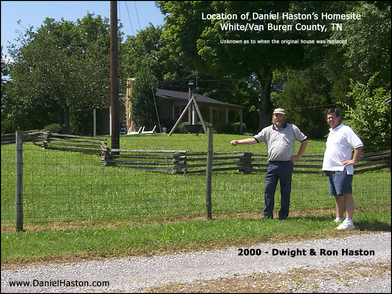
Daniel Haston's 150 acres of land was equal to the size of the other three pieces of land combined. Not only did he acquire the largest tract, but his tract was also best situated with reference to Big Spring. The head of the spring was apparently located on his property, since his property line (that bounded Joseph Haston's tract) passed "through the head of the Big spring." The spring then flowed 132 feet (eight poles) before leaving his land and crossing the line into Jacob Mitchell's tract. Daniel's prominence in this land cluster was probably due to his patriarchal status, as well as the larger size of his claim.
Daniel's land, as well as the land of the other Big Spring families, was purchased from a Davidson County, TN land speculator, Thomas Dillon. Dillon had ostensibly acquired the land from Andrew Jackson's brother in law, Stokley (Stockley) Donelson. This particular tract of 5000 acres was one of several that Dillon supposedly purchased from Donelson, which he subdivided and sold to early middle Tennessee settlers. The base tract of 5000 acres is identified in the Haston, Bradley, & Mitchell grants as "Certificate No. 63." We have not been able to determine if Dillon did, in fact, purchase it from Donelson or how Donelson acquired it. There are some reasons to believe that it might have been one of Thomas Dillon's known land scams. No purchase price is indicated in any of the land transaction documents available to us, but the Thomas Dillon involvement in these land grants indicates that these were not free grants from the State of Tennessee, but paid transactions between Dillon and the settlers. As far as we know, this is the first property that Daniel Haston lived on that belonged to him, even though he was more than fifty years old at this time. In Virginia, he lived on 400 acres of mountain land in Powell's Fort Valley that belonged to his father. In Knox County, he leased land from a John and Jane Wood, south of the Holston River, opposite Knoxville. Apparently, he had been saving money through the years for this realized dream of becoming a property owner. Sources: Pages 108-109 of White County, TN Deed Book C. Also, Certificate of Survey for Tennessee General grant # 535 from the Tennessee State Library and Archives. Also, Land Grant Mountain District Book 4, page 49, roll 155 (September 26, 1808 & recorded October 31, 1808).
|
|
Joseph Haston (see the Joseph Haston section) There is no mystery associated with the identity of Joseph Haston. Various sources clearly identify him as Daniel's son. Joseph, it could be argued, received the second best location in the land cluster. The head of Big Spring was situated on (or very near) the boundary of his and Daniel's land, according to the description in Daniel's survey. But the fact that Joseph's survey doesn't mention his property line passing through the head of Big Spring may indicate that the spring head was actually only on Daniel's property. Big Spring flowed 495 feet down Joseph's northwest property line. The mystery associated with Joseph's purchase is why he would officially locate the claim on August 28, 1807, survey it on Jun 18, 1808, finalize the transaction on September 20, 1808 and then sell it to his brother, David Haston, five months later on February 15, 1809. Perhaps David Haston's late arrival to this area is a clue. On September 11, 1806 David was still in Knox County, TN settling the sale of 111 acres of land to Ezekiel Baldwin for $490.00. His first known appearance in White County was February 10, 1808 as a road worker. Maybe Joseph was commissioned by David to purchase the White County land and hold it for him until he could settle his Knox County business, move to White County, and settle his family. The tax records indicate that Joseph did not own land again until 1817. At that time he acquired 20 acres "on the Caney Fork." We do not know the specific location. Then he apparently inherited 50 acres of his father's land in 1823, prior to his father's death. David (being the eldest son) probably inherited the Daniel Haston home place on the east end of the 150 acres tract, but we do not know which portion Joseph inherited. By 1826 he had been granted 66 acres "south of the Caney Fork." His taxable total acreage in 1827 was 169 acres, but that dropped to 100 acres in 1828. Where did Joseph live during the 1809-1817 years in which he owned no land? Perhaps he lived on Daniel's or David's land. Sources: Grant # 550 on page 64 of Volume B of Deeds of White County, TN; Grant # 550 on page 239 of TN G District, Book A and page 64 of the TN MTN District, Book 4 (1808). Also, General Grant # 550 Certificate of Survey, available from Tennessee State Library & Archives in Nashville, TN.
|
|
Jacob Mitchell Download Timeline of Jacob Mitchell & Related People (33 pages - PDF file) Although Jacob Mitchell's land did not have direct access to the head of the spring, his property line ran along Big Spring branch for some 1500 feet, which gave him more frontage to the stream than any of the four Big Spring area tracts. It could be argued that he, not Joseph, received the second best location. Why was he given such a prominent location? There is evidence to indicate that he was probably a son-in-law of Daniel Haston. It has been said that there is a Morris Mitchell family Bible which contains an entry indicating that Jacob Mitchell was married to Lucinda Hastings (no date given). The Bible was supposedly passed down to his son, Stephen Mitchell, who passed it down to his son, Frank, who passed it down to his daughter, Rachel Caroline, who passed it down to her son, Glenn Cowan. It became known as the Cowan Bible. Glenn Mitchell Cowan was born in 1910 and had at least one daughter, Carnation Cowan. Source of the above information: LuAnn Penrod Smith There is a known Bible record of the Morris Mitchell family, but it is probably from the Bible of Morris Mitchell's son, Stephen (brother of Jacob and James). Thus, it does mention the birth of Jacob Mitchell but not his marriage. If you have information related to evidence of a Jacob Mitchell - Lucinda Hastings marriage, please contact us.
Thomas C. Mitchell (great grandson of Morris Mitchell), sometime before the mid-1920s, indicated in his record of the Morris Mitchell family that Jacob Mitchell married "Lucyna Hasting." If Jacob Mitchell's wife was Lucinda Hastings, then it would seem likely that Jacob was the son-in-law of Daniel Hastings/Haston. That would explain why Jacob was included in this close community of early White County settlers. Although "Lucinda" (or "Loucinda") was a popular name of that era, it may be significant that David and Peggy Haston named their third daughter "Loucinda." It was a common practice for parents to name children after their siblings, particularly when they had a close, ongoing relationship with the siblings. Here are some of the additional things that we have learned about Jacob Mitchell, primarily from various Mitchell family researchers, such as Virginia Mitchell Barry and LuAnn Penrod Smith (lujac@comcast.net):
Major source for Jacob Mitchell information: No. 2, "Jacob Mitchell" in chapter two or The 720 Descendents of Morris and Elizabeth Mitchell. Sources for White County real estate deed: General grant # 50 Certificate of Survey, available from the Tennessee State Library & Archives in Nashville, TN. Also, page 62 from Volume B of the White County, TN Deed Books and page 20 of White County, TN Deed Abstracts (1801-1820) as abstracted by Joyce Martin Murray. |
|
Isham Bradley's relationship to the Daniel Haston family can be traced back to Knox County, TN. Isham was the bondsman for David Haston's May 5, 1800 marriage to Peggy Roddy. What we do not know is what that relationship was specifically. Was he a relative to the Hastons or was he just a friend? According to the Blount County, TN marriage records Isham (Isom) Bradley married Susana Matlocks on May 13, 1798 in Blount County.* So apparently he was not a son-in-law of Daniel Haston, as Jacob Mitchell may have been. Whatever the relationship was, it was strong enough for him to travel to the wilderness of middle Tennessee in order to settle adjacent to the Haston family (even before his friend David arrived to the area). If you have information concerning Isham Bradley, please contact us.
|
|
Nicholas Gillentine (1776-1834) was the father-in-law of Daniel Haston's son, Jesse, who married Elizabeth Gillentine in 1815. Although the Gillentine and Haston families appear to have lived in Knox County, TN at the same time, we know of no relationship between the two families prior to their settlement in White County, TN. Nicholas was a prominent civic leader in the early years of White County. He was one of the original commissioners for the town of Sparta, TN, as well as a justice of the peace, as early as 1813, for the area where the Haston families lived. He was also a prominent Baptist leader wherever the went. In 1806, he had been a messenger from the Beaver Ridge Baptist Church to the Tennessee Association of Baptists. In October of 1807, he was a messenger to this same association from the East Fork of Poplar Creek Church in Anderson County, TN (north & west of Knox County). Then, less than a year later (4th Saturday of September, 1808) he appeared as a messenger from the newly formed Big Fork Baptist Church in the Big Spring area of White County, TN to the Stockton Valley Association meeting. His leadership in that church continued for several years. It appears that the Big Fork Baptist Church and Cemetery were located on land owned by Nicholas Gillentine at the time of the church's founding. Given the prominent role that he had in that church's early years, this is not surprising. Nicholas Gillentine possessed the tract of 139 acres situated on the north line of Daniel Haston's property as early as (and probably earlier than) January, 1812. Here is what we know about the history of that tract of land:
From a comment that appears in an 1822 land grant description, it appears that Nicholas Gillentine mined for lead ore somewhere near his property. A September 21, 1822 survey for five acres of land purchased by John Gillentine indicates that this five acre tract was "including the place where N. Gillentine has been working for lead oar [sic]." This land was located "on the waters of Cane Creek in a cove of Cumberland Mountain." (Source: Grant #24210 on page 23 of TN General District Book BB, available at the TSLA in Nashville, TN) Here are some additional basic facts that we know regarding Nicholas Gillentine.
A 1930 thesis, Legends and Stories of White County, Tennessee by Coral Williams, contains two paragraphs about Nicholas Gillentine the bear hunter. For more information on the Gillentine and Terry families, contact Sue Tiffany Webb. |
|
The main question with regard to David Haston and this cluster of Big Spring settlers is why he was not a part of the original group. The answer is probably related to the fact that he was (as far as we know) the only member of the Haston family who owned land in Knox County, prior to the family's migration to middle Tennessee. On September 11, 1806 he was involved in the sale of his 111 acres on Grassy Creek in Knox County. We know that he was there at least until October 11, 1806. It seems probable that David commissioned Joseph to purchase 50 acres on Big Spring for him, which would be transferred to him upon his (David's) arrival to White County. The $409 dollars (in 1806) that he made off of his Knox County 111 acres easily paid for the 50 acres he purchased from Joseph in White County in 1809 for $200. The 50 acres he purchased from Charles Mitchell (which was originally owned by Isham Bradley) cost him $610 just three years later in 1812. These 100 acres were all that David owned until he inherited 50 acres from his father's place, when Daniel died in 1826. Daniel Haston, apparently, had given 50 acres of his land to Isaac and 50 acres to Joseph by 1823, keeping 50 acres and the home place for himself until his death. When he died, apparently David inherited the final 50 acres and the home place. We would assume that David Haston's house, at least until the time his father died, was situated east of Daniel's "Haston Station" place, either on the land he purchased from Joseph or the land he purchased from Charles Mitchell (originally owned by Isham Bradley). Soon after David inherited 50 acres from his father, he purchased 100 vacant acres (on February 5, 1827) for the meager price of one cent per acre. It was probably steep mountain land that was only good for cutting timber or rail wood or firewood. He made a similar purchase of 71+ acres a few years later (July 27, 1829). This appears to be the extent of David Haston's land acquisitions, except for the seven town lots he purchased in 1848 in Spencer, TN. See the Land Acquisitions Chart on the David Haston timeline for a summary of David's real estate activity.
|
|
|