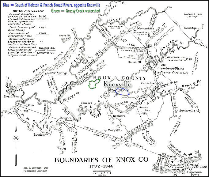
The Heritage of Daniel Haston


Probable Haston Family Home Locations
1790s-1807  Knox County, Tennessee


Daniel Haston Family (1790s-1802)
"South of the Holston River, Opposite Knoxville"
(area enclosed by blue is most likely the general area where Daniel Haston's family lived)

We do not know if Daniel and his family lived in more than one location during his Knox County sojourn, nor do we know where he lived prior to December of 1797, if he did live in more than one Knox County place.  The following evidence suggests that his family lived somewhere in the area between the Holston River (south of Knoxville) and the Bount County line, from the late 1790s to the earliest years of the 1800s.  It is probable (from a variety of non-conclusive clues) that they lived a short distance from the Holston River, not very far from Knoxville.

Note:  The river that flows south of Knoxville is now known as the Tennessee River (specifically, it is now Fort Loudon Lake* on the Tennessee River).  Previous to 1874, the part of the river that was east of Kingston, TN was known as the Holston River. 
Source:  Goodspeed's History of Tennessee Illustrated: Knox County (1887)

*Note: The Fort Loudon dam, a few miles southwest of Knoxville, was completed in 1943.  Prior to that time the Tennessee River ("Holston River" prior to 1874) would have looked very differently to the way it appears now.  The river in that area now is the backwaters of Fort Loudon Lake.  Thus, it is now wider, much deeper, and appears to flow more slowly than it would have prior to the creation of the lake.

Summary of the Evidence Stated Below

 Where did Daniel Haston's family live in Knox County, TN?

Daniel Haston lived on land rented from John & Mary Wood of Maryville, TN, which was handled through Wood's agent, James Charter.  We have not yet located where that property was, but we do know that it was south of the Holston River (now the Tennessee River or Fort Loudon Lake) and across from Knoxville.

Based upon the locations of families who repeatedly appear to have been Daniel's neighbors, it seems that he lived somewhere in the area south of the Holston River and southwest of the French Broad River, which flows into the Holston (Tennessee) River just southeast of the main part of Knoxville.  It is probably a safe educated guess to say that he lived within three miles of Knoxville, somewhere in this French Broad River - Holston (Tennessee) River wedge of land.  One piece of evidence suggests that he may have lived somewhere along one of these rivers, which might make his home location considerably closer than three miles to Knoxville.

 
  • Knox County, TN Road Order Book, 1792-1819 (available on microfilm at the Knox County, TN Archives in Knoxville; also, available at the Lawson McGhee Library in downtown Knoxville, TN)

On page 18 of the Knox County, TN Road Order Book (1792-1819) Daniel Haston is mentioned as a member of a road jury made up of men who are known to have lived adjacent to or near each other in the area of Knox County, "south of the Holston River, opposite Knoxville."  Court records (see below, as well as the Daniel Haston timeline) indicate that Daniel Haston had dealings with Paul Cunningham, Nathaniel Hays, and James Charter on other occasions.

The following persons were appointed as Jury to wit, Paul Cunningham, Nathaniel Hays, Francis Cunningham, Daniel Hastings and James Charter, for the purpose of reviewing a road from the new Ferry landing on the south side of Holston opposite to Knoxville unto the old road leading to Tellico Blockhouse, to report to next Court whether any disadvantage doth arise to the Citizens from the alteration and whether any disadvantages would arise from making the old landing and road so far as to where the new road strikes it obsolete.

Who at the October Sessions reported as follows.
We the Jurors appointed to view the Road from the new ferry landing with the old Tellico road, and Boyds Creek road being met and duly sworn to report as follows, to wit. From the new landing with the Boyds creek road to the farthest corner of Charter's lots, and along the end of said lots, thence as the old waggon road runs to where a heep of bark is piled in the road, and conceive no disadvantage by attesing (?) the landing.  Signed by the Jurors. 

[Note: This must have been copied by a clerk from the original document written by the jurors, since no jury signatures are found here.]

It is very possible that Daniel Haston lived on one of the lots referred to above as [James] "Charter's lots."  Charter may have (or probably) owned some land in this area, but he also was an agent for John & Jane Wood, from whom Daniel Haston leased his land.

  • Knox County, TN Court Case File: Docket # 1385/1235, Samuel Cowan vs Joseph Hasting (1800-1801)  [Also: Pages 76-78 of WPA transcribed Records of Knox County, TN Minute Book, No. 3, 1800-1802]

This court case, which began early in 1800, states clearly that Daniel and Joseph Haston lived "on the South side of Holston River opposite Knoxville."  At this time, Daniel Haston was living on land rented from John & Jane Wood (or Woods) of Maryville, TN (Blount County) and the Woods' agent was James Charter.  This land was adjacent to land owned by the plaintiff, Samuel Cowan, a well known merchandiser in Knoxville.

To this point, we have been unable to locate a deed or survey for the "south of the Holston, opposite Knoxville" land owned by either Samuel Cowan or John & Jane Wood.  If you have documentation regarding these pieces of property, please contact us.

Samuel Cowan, the plaintiff in the case, owned a ferry that crossed the Holston River at the southeast corner of Knoxville.  This is the same ferry that Richard G. Waterhouse leased from the heirs of Samuel Cowan in January of 1803, a couple of years after the conclusion of the Cowan vs Haston case and the death of Samuel Cowan.  In his journal (page 136 & elsewhere), Waterhouse* referred to this area, just across the Holston from Knoxville, as the Iredell community.

James Cunningham, son of Paul Cunningham, Sr., was summoned to witness on behalf of Joseph Haston.  This Cunningham family was known to have lived in the area described by that phrase.  James Charter (agent for Jane and John Wood) also owned property in this section of Knox County (see page 140 of the Richard G. Waterhouse journal).

*Richard Green Waterhouse (1775-1827): Tennessee Pioneer by Elizabeth Waterhouse Layman. Wolfe City, TX: Henington Publishing Company, 1996.


  • State vs David Haston & Joseph Haston; Knox Co, TN County Court of Pleas and Quarter Sessions; Docket # 796/65 (1798)

Circumstantial evidence in this case would suggest that the Haston family lived in the same area, in late 1797, where they lived later, in 1800.

Nathaniel Hays, the plaintiff, in this case was known to have lived in south Knox County, south of the Holston River.  Also, two of the witnesses who were called to testify for Hays, William Haslet, Jr. and William Haslet, Sr., were known to have lived in this area south of the Holston. 

The case summary mentions that William Haslet, Jr. "rode in to the Island" to track the blood of the cows whose tails David Haston was accused of cutting.  The "island" reference may provide more specific clue as to the location of the Haston home.  Assuming the event in this case occurred near the Haston farm, it must have been close enough to a river that was large enough to create an island.  That most likely would have been the Holston River.  If so, then it would indicate that Daniel Haston's family lived a short distance from Knoxville, south of the Holston River.


  • Governor John Sevier's Journal

"After Tennessee became a state on June 1, 1796, the Governor was required by law to live in the capital; however, his family did not arrive in Knoxville until the following year." "Governor Sevier liked farm life, and did not agree with most residents of the capital city that log houses were passé. He purchased a plantation south of the river, not far from his former militia headquarters near the Indian towns, and christened it 'Marble Springs.' There he built a log house very similar to Plum Grove (his Washington County home), and surrounded it with outbuildings." 

Source:  Page 49 of Knoxville by Betsey Beeler Creekmore, published 1991 by the East TN Historical Society


As the map above indicates, Sevier's Knox County plantation was located south of the Holston, opposite Knoxville, possibly very near the home of Daniel Haston's family.  Numerous references in the John Sevier journal suggest that John Sevier and Daniel Haston lived in the same neighborhood.

  • Tuesday, June 23, 1796:  "Mr. Haislet Junr. reaped part of the day.  Haislet Senr. a whole day."*  Note:  These are probably the men (William Haslet, Jr. and William Haslet, Sr.) who witnessed against David Haston in the 1797-1798 Knox County "cow tails" case.  They, almost surely, were Knox County neighbors to the Daniel Haston family in late 1797.  However, it appears that, on this date, John Sevier was reaping on his Plum Grove plantation on the Nolachucky River, about ten miles from Jonesboro, TN.  Had they not moved to Knox County at this time?  Did they move there later, because of some connection to John Sevier?  They certainly lived near his Marble Springs farm in late 1797.  *Source:  Journal, page 188
  • Friday, August 12, 1796:  "Let Suza Haiston have 1 dollar recd. from her melons &c to the amt. of 4/."*  The journal seems to indicate that Governor Sevier was in Knoxville at the time of this payment to Suza Haiston.  Was this Suza a member of the Daniel Haston family?  Perhaps they lived so close to him that he purchased vegetables from them and Suza stopped where he was staying at the time, in Knoxville, to collect what he owed or delivered vegetables to him.  *Source:  Journal, page 189.
    Note:  On Thursday, October 20, 1796, John Sevier "paid unto Mrs. Hairston 3 dollars in full of all accompts." (Journal, page 191)  Was this "Mrs. Hairston" the same lady as "Suza Haiston?"
  • To travel from Knoxville to his Marble Springs plantation, John Sevier apparently took the ferry that was originally owned by Alexander Cunningham, then later by Samuel Cowan, and later by Richard G. Waterhouse (and others later).  This ferry may have landed south of the Holston near where the Haston family lived.  Both Samuel Cowan and a member of the Cunningham family (James Cunningham) were associated the "timothy lot" court case involving land where the Hastons lived.  According to his journal, Sevier paid "Roddy the ferryman 15s 4d" on Wednesday, December 5, 1798 (page 255) [Also, May 6, 1799 & January 10, 1800].  Was this one of the Roddys with whom the Daniel Haston family was associated?  He must have been employed by Samuel Cowan who owned that ferry at the time of these entries. 
    Source of Cunningham-Cowan-Waterhouse ferry information: Tennessee Anthropologist, Volume XVI, Number 2, Fall, 1991.

Source:  Journal of Governor Sevier (1790-1835) as transcribed by John H. Dewitt and published in the Tennessee Historical Magazine on pages 156-194 in Volume 5, #3 (October 1919) & on pages 232-264 in Volume 5, #4 (January 1920) & on pages 18-67 in Volume 6, #1 (April 1920).


  • Cunningham Family Evidence

There is abundant evidence (Knox Co, TN court records, deeds, etc.) to prove that there was a well known Cunningham family that lived south of the Holston and opposite Knoxville in the 1790s and early 1800s.  The progenitor of this family was Paul Cunningham, who was one of the original commissioners of Knoxville and died on March 8, 1805 in Knox County. 

According to Cunningham researcher, Sharon Webb, Paul Cunningham "settled across the river, about three miles from Knoxville."  She also states that his "final resting place is in a family cemetery overlooking the bluffs along the Tennessee River in South Knoxville."  Source:  "Cunningham Family and Paul Cunningham Letter (Knox Co, TN, 1796)," an article in the December, 2002 issue of Tennessee Ancestors (Volume 18, Number 3). 

Location of Cunningham Family Cemetery - South Knoxville, TN
Location of Cunningham Family Cemtery - South Knoxville, TN

The same Nathaniel Hays who took David Haston to court in the "cow tails" case, took Paul Cunningham to court for a dispute regarding property boundaries.  The Hays vs Cunningham case reveals the following information regarding where these neighbors of Daniel Haston lived:

  • Nathaniel Hays
    • South side of the French Broad River, property line began on the river bank
    • Adjacent Paul Cunningham, Senior
    • Adjacent to Archibald Rhea lands
  • Paul Cunningham, Senior
    • Near Knoxville
    • South side of the Holston River, property line began on the river bank
    • Some "rock house" on the Holston was a marker point
    • Near, but does not cross the Meadow Branch
    • Adjacent to William Haislet
    • Adjacent to Cowan; along this line to the river
    • Originally called the Baker improvement
    • Purchased from James White in mid-1780s

Nathaniel Hays and Paul Cunningham had been involved in a previous (1800-1801) Hamilton District Superior Court case (Nathaniel Hays vs Solomon McCampbell and Paul Cunningham) involving a similar property boundaries suit.  From the narratives of that case, we can learn more about the land that they possessed:

  • Nathaniel Hays purchased his land from Solomon McCampbell in 1792.
  • Hays land was on the south side of the Holston (as well as south of the French River, as per the Hays vs Cunningham case).  It seems that the banks of both of those rivers formed part of his property lines.  His land met the property lines of Haislet and Archibald Rhea on the river bank (seems to refer to the Holston River bank).
  • His land was only about 1 1/2 miles from Knoxville (as was the home site of Paul Cunningham).
  • Paul Cunningham purchased his land (640 acres) in 1785 from James White, who had purchased it from a Captain Baker.  Paul Cunningham then sent his sons, Alexander and James, to improve it and develop it.
    Note: Alexander Cunningham started a ferry from this land (that later was sold to Samuel Cowan and later to Richard G. Waterhouse, and others later).  This was the ferry that John Sevier used in his trips from Knoxville to his plantation home, which was located in this south of the Holston, south of the French Broad area.
  • Cunningham's land had about 500 feet of frontage on the Holston River.
  • Paul Cunningham moved his family to this land in December 1797.
  • Cunningham's land adjoined Haislet land along a "Meadow Branch" which belonged to Haislet.
     

  • Journal of Richard G. Waterhouse

    Richard Green Waterhouse (1775-1827): Tennessee Pioneer by Elizabeth Waterhouse Layman (Wolfe City, TX: Henington Publishing Co, 1996); order from Beth Layman (elayman@houston.rr.com)

Although the Richard G. Waterhouse (RGW) journal does not mention Daniel Haston nor any of his family members, Waterhouse lived in this "south of the Holston, south of the French Broad" area and operated the ferry that was started by Alexander Cunningham.  He often referred to the area as "Iredell."  His sojourn in this specific area overlapped that of Daniel Haston for approximately four years.  They had several (probably many) common acquaintances and lived near each other, thus they must have known each other fairly well. 

  • RGW had dealings with James Charter, who was John & Mary Wood's land agent and was mentioned in the Samuel Cowan vs Joseph Haston "timothy lot" case.
  • He had many very close dealings with the sons and daughters of Phillip & Mary McComesky Roddy.
  • Rented the ferry owned by Samuel Cowan, before his death (ferry originally owned by Alexander Cunningham).
  • He had close dealings with the William ("Fighting Billy") Tipton family and married his daughter, Polly.  William Tipton was one of Daniel Haston's securities for the James Roddy estate settlement.
  • Buried his son in "Mr. Cunningham's Burying Ground."  This was probably the family cemetery on John Cunningham's property, as described in Sharon Webb's article (see above).  If so, it overlooked the Holston (Tennessee) River on a bluff across the river from Knoxville. 

David Haston Family (1802-1806)
"East Fork of Grassy Creek"

 (area enclosed by green is Grassy Creek watershed area)
 

Summary of the Evidence Stated Below

 Where did David Haston's family live in Knox County, TN?

From October 28, 1802 to September 11, 1806, David Haston owned 111 acres in the western part of Knox County, TN.  His land was clearly described as being on the "East fork of Grassy Creek."  That would indicate that his land was somewhere in the eastern section of the Grassy Creek watershed area.  We assume that he lived on this land during the four years that he owned it, just prior to his move to White County, TN.


David Haston's Grassy Creek Land Documents

On October 28, 1802, David Haston purchased 111 acres in Knox County, TN from John Armstrong.  The location of David's land was described by these identifying features:

  • lying and being in the County of Knox and State aforesaid [Tennessee]

  • on the East fork of Grassy Creek

  • adjoining Jonah Armstrong on the lower part where Joseph Lea formerly lived

  • and Isaac Pruet on the upper part formerly held by Kelly

  • Beginning as flows at a stake on the bank of the creek at the same place where Kelly’s line strikes said creek

  • thence south forty degrees East twenty five poles crossing the creek more or less crossing the creek to the original line of the same survey

  • thence along that line South fifty degrees West one hundred and forty poles more or less to a hickory and white oak agreed upon as boundary between John Low (Loe) and the Sr Joseph Lea

  • thence north thirty eight degrees East forty poles more or less to the creek -

  • thence down said creek to a poplar and elm on the bank of said creek a small distance above a (lick?)

  • thence North ca. fifty degrees East one hundred and sixty pole, more or less to Kellys line -

  • thence along that line South forty degrees East to the Beginning.

On September 11, 1806, David Haston sold this 111 acres in Knox County, TN to Ezekiel Baldwin.  The location of David's land was described by these identifying features:

  • lying and being in the County of Knox & State of Tennessee on the East fork of Grassy Creek,

  • adjoining Francis Johnson on the lower part where Joseph Lea formerly lived

  • and Isaac Pruit on the upper part formerly held by Kelley

  • Beginning as follows at a Stake on the Bank of the Creek at the same place where Kelleys line strikes sd Creek

  • thence south forty degrees East twenty five poles crossing the Creek more or less to the original line of the same survey

  • thence along that line South fifty degrees west one hundred and forty poles more or less to a Hickory & white oak agreed upon as a boundary between John Loe and the said Joseph Lea

  • thence north thirty eight Degrees East forty poles more or less to the Creek,

  • thence Down said Creek to a Poplar & Elm on the Bank of said Creek a Small Distance above a Lick,

  • thence north fifty Degrees East one hundred and Sixty poles more or less to Kelleys line,

  • thence along that line South forty degrees east to the Beginning

David Haston's Grassy Creek Land in Knox Co, TN


Some Families of the General Grassy Valley Area
of Early Knox County, Tennessee

The common denominator for most, if not all, of the families on the following chart is that they lived in the same general area of the west-northwest area of Knox County, TN.  Some of these families later moved to the same general area of White County, TN, at about the same time.  There were numerous inter-marriages between and among these families.

Stickley-Creely-Pruitt-Haston, etc. Relationships

For more detailed information on the above families, go to the
"Miscellaneous Family Relationships, Knox County, TN - White County, TN" page.