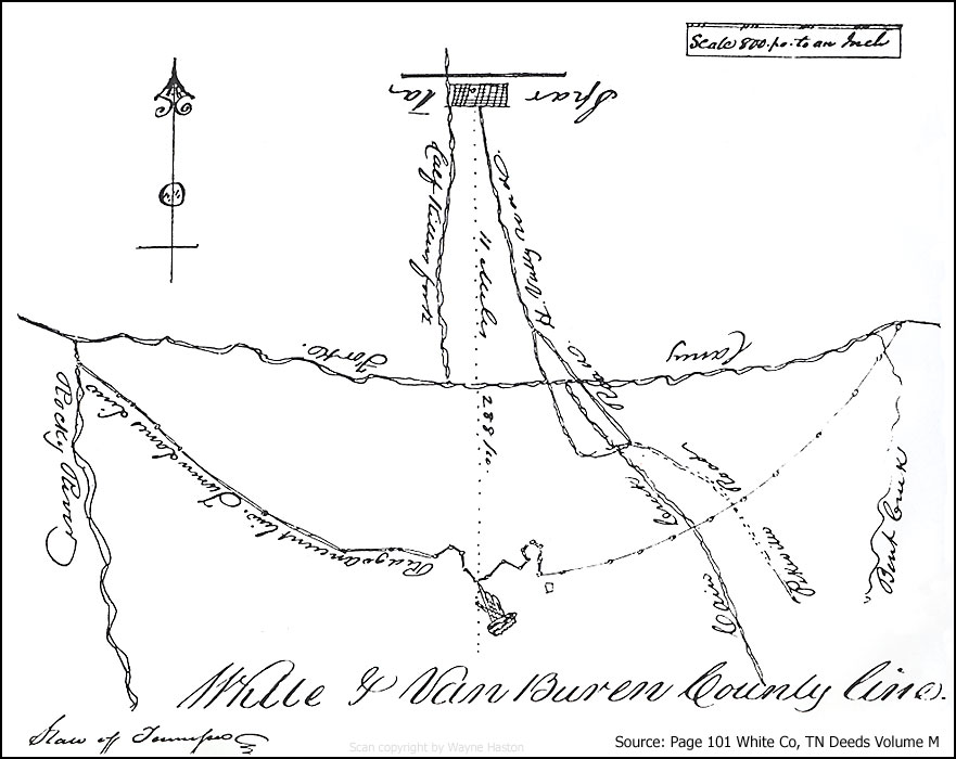
Why was the White County & Van
Buren County line located on the ridge of the mountain on
this map?
| The early records of Van Buren County
clearly indicate that occupants of the area south of the
Caney Fork, including what is now called Cummingsville
and westward over to Sparkmantown, were included among
the earliest citizens of Van Buren County. One of
the strongest arguments for the creation of Van Buren
County was the presence of the Caney Fork River that, in
wet seasons, made it difficult for people of this area
to access White County's county seat of Sparta, which
was well north of the Caney Fork.
Why then, did Jonathan C. Davis set
the White and Van Buren County line on the top of the
ridge, south of the Caney Fork River? Was this a
wishful attempt, on the part of White County, to retain
the area between the mountain's ridge and the Caney Fork
River as a part of White County? At the time this
survey was presented and recorded (January 1841), Van
Buren County had already been officially established and
was functioning.
Please contact Wayne Haston (waynehaston@aol.com)
if you have information concerning this survey. |
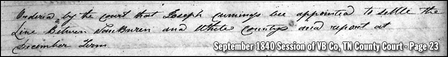
Pursuant to an order of the worshipful County Court
of White, appointing Jonathan C. Davis, Esq. to run and mark the
line between the Counties of White and Van Buren as his legally
authorized Deputy. I proceeded to the execution of said service
on the thirteenth day of November A.D. 1840. Beginning at the
Court house in the town of Sparta and running thence South crossing
the Caney fork at seven miles and eighty eight poles in all Eleven
miles and two hundred and eighty eight poles to the extreme height
of the ridge which divides the waters of Laurel Cove, Rocky river
and Caney fork being the ancient boundary line between the counties
of White and Warren. In running this line I caused the chain to
be leveled and plumbed, thus reducing said line to Horizontal
measure, this fixing and ascertaining the distance to be Eleven
miles and two hundred and eighty eight poles, falling short of
twelve miles thirty two poles, and believing that I could not go
beyond the ancient boundary of White County I terminated my
measurement at this point. I then proceeded to run the line
between said Counties of White and Van Buren in a north westwardly
direction. Beginning at the Index as noted for the meridian
line of Sparta, represented by the dotted line and running thence
south seventy and one half degrees west one hundred poles to a point
precisely twelve miles from Sparta, thence north forty eight degrees
west one hundred and eight poles to a stake1, thence
north thirteen and one fourth degrees west one hundred and twenty
poles to a stake2, thence north fifty six and a half
degrees west seventy fours poles to a stake3, thence
south sixty eight degrees west one hundred and twenty two poles to a
stake, thence north eighty one degrees west one hundred and forty
poles to a stake, thence north fifty degrees west one hundred and
sixty four poles to a stake, thence north eighty degrees west forty-forty two poles
to a stake near Fanny Priests, thence north eighty eight degrees
west estimated at three hundred and sixty poles to the top of the
ridge between the Arch and Bone Caves including the Bone Cave in
White County, the whole of the above lines are run upon and near the
top of the dividing ridge which was formerly the line between the
Counties of White and Warren. From the top of the ridge
between the Arch and Big Bone Caves I have adopted the line as
formerly run by Turner Lane Senr. Esq. from thence to the mouth of
Rocky River being the boundary line between the Counties of White
and Warren, being well satisfied that nopoint therein, is said boundary
twelve miles distant from Sparta, and therefore did not run, that
portion of said line. And in the further progress of running
and marking said line I again returned to the point due south of
Sparta. Beginning at the Index noted on the meridian line of
the town of Sparta and running thence up the extreme height of the
ridge dividing the waters aforesaid north seventy five degrees East
thirty poles to a stake, thence north forty one and a half degrees
East eighty eight poles to a stake, thence south sixty eight and one
half degrees East one hundred and thirty six poles to a ___ thence
north(?) 36o east 21 (?) poles to a stake thence north two
degrees west thirty eight poles to a stake, thence north forty four
and a half degrees east eighty poles to a stake, thence south
seventy degrees east fifty two poles to a stake thence south twenty
two and one fourth degrees east twenty eighty poles to a stake
thence south one degree west one hundred and eight poles to a stake
and pointers in the Ancient boundary line between the County of
White and Warren distant twelve miles from Sparta and between one
fourth and one half mile distant from Spencer the County town of Van
Buren County, the whole of the __ named courses being run as
nearly as practicable upon the extreme height and middle of the
dividing ridge aforesaid, -- thence north seventy eight degrees east
two hundred and sixty eight poles to a stake, thence north seventy
degrees east two hundred and eighty poles to a stake, thence north
sixty five degrees east two hundred and twenty poles crossing Cain Creek near
William B. Hastings and just above his house, course continues one
hundred and twenty poles in all three hundred and forty poles to a
stake, thence north sixty eight degrees east crossing the Pikeville
road at two hundred and ninety eighty poles course continues in all
three hundred and twenty poles to a stake, thence north fifty five
degrees east three hundred and eighty poles to a stake, thence north
fifty degrees east four hundred poles to a stake, thence north forty
five degrees east four hundred and seventy (twenty?) poles to a stake, thence
north thirty nine degrees east three(?) hundred and forty poles to a
stake on the south bank of Bent Creek, thence north thirty two
degrees east to the Caney fork estimated at three hundred poles the
whole of which lines I __ to be plainly and distinctly marked by a
blaze and two chops above and two below and is fairly represented by the
within platt. All of which is most respectfully submitted to
the consideration of the worshipful for its approval and
confirmation.
Jacob Lane
Deputy Surveyor
State of Tennessee
White County
January term 1841 of White County Court. This
day Jacob A. Lane Deputy Surveyor returned his report with a platt
annexed of the line run between the Counties of White and Van Buren
which is confirmed by the Court and ordered to be and Registered in
the Registers office of White County.
Given at office the 4th day of January A.D. 1841
Test N. Oldham clerk of White County Court
Registered 16th January A.D. 1841
Test N. Oldham Deputy of__ Register White County
Source: Pages 101-103 of White County, TN
Deed Book M, TSLA microfilm roll # 63.
|