|
South Fork of the
Shenandoah River Property
(What is now Page County,
VA)


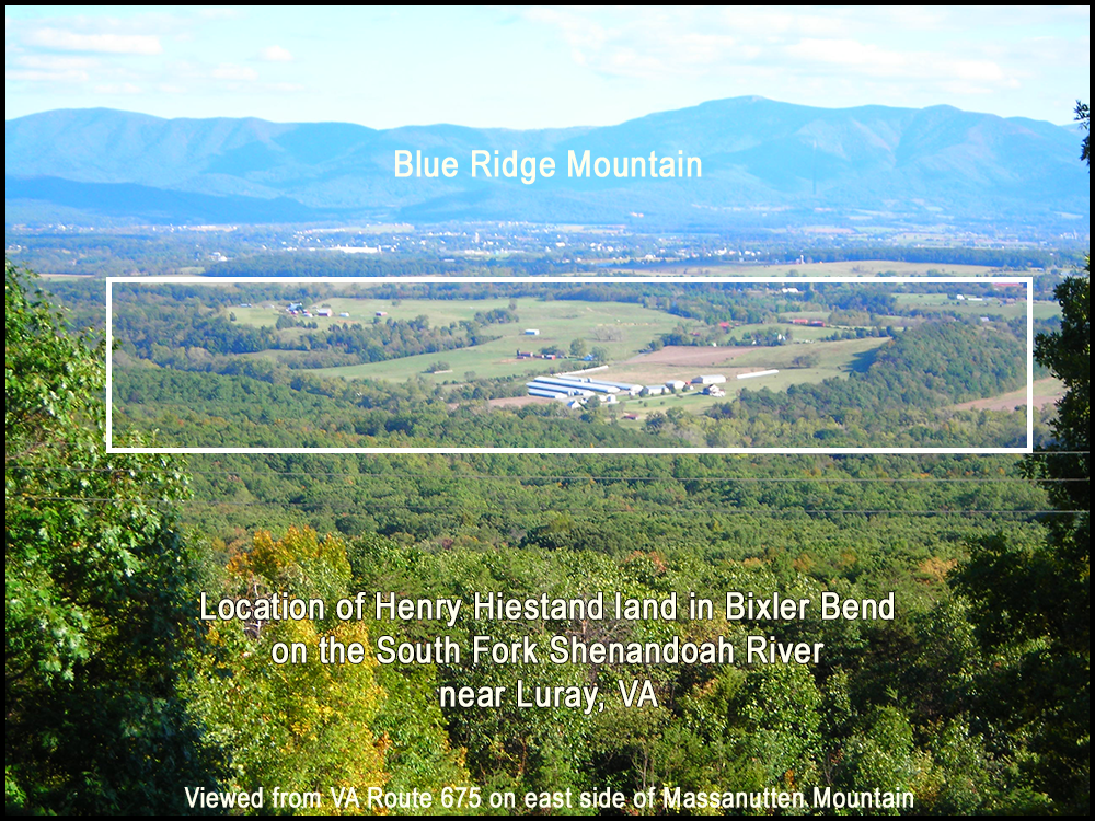
Henry Hiestand's South Fork of Shenandoah River
Property
"Cursor over" the
above image to see the land inherited by sons Jacob, John, and Peter in
1777.
What is the explanation for the
discrepancy between what appears to be a total of 469 acres that
Henry acquired in 1743 (205 acres) and 1762 (264 acres) AND the total
amount of land (792 acres) three of his sons inherited from him in 1777?
For possible explanations - read the section
below.
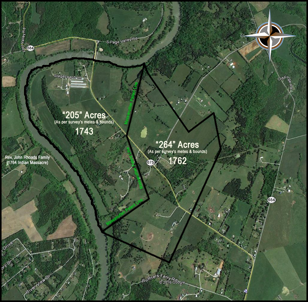
| 205 Acres Tract - 1743
Although we have no reliable date for the
birth of Daniel Haston, given a number of factors - such as
the date of his marriage to Christina Nave, date of his
children's births, later court records, etc. - it is likely
that he was born in about 1750. Therefore it is also
likely that Daniel was born on this South Fork Shenandoah
River homestead of Henry Hiestand's family.
Philip Long (b. 1680 c.) purchased 205 acres and 800 acres
on the east side of South River Shenandoah from Ludwick
Stone for 100 pounds on 22 March 1737/38. (Tract 111E,
Map 14) The 800-acre tract was the northernmost and
its south line was the mouth of Stoney Creek. Page
County Highway 634 west of Highway 616 proved access to this
property on the north and Highway 616 north of U.S. Highway
340 runs along the southeast property line.
The
following information is very inaccurate. The 205 acre
tract that Philip Long sold to Henry Heastand was not in the
Alma, VA area. It was several miles farther down the
South Fork Shenandoah River in what was later called Bixler
Bend, where the current Bixler Ferry Road (on VA Route 675)
crosses the river.
The southern
205-acre tract was located at present-day Alma, Virginia and
is accessible by U.S. Highway 340 and Page County Highway
650 from Alma to the mouth of Honey Creek at the south
property line. Philip sold the
205-acre tract to Henry
Heastand for 54 pounds, 16 shillings and 6 pence on 21
September 1743.133
133Orange County, Virginia Deed Book 2, p. 260; Book
7, p. 417.
Page 453 of Pioneers of Old Frederick County Virginia by
Cecil O'Dell (Westminster, MD: Heritage Books, 2007)
This 1743 survey appears to be
incorrect and Henry seems to
have been the beneficiary of an extra 100 or so acres in
this real estate deal with Philip Long.
|
Pages 417-418 of Orange County, VA Deed Book 7
The tract that Henry purchased in
1743 was supposed to contain 205 acres "more or
less." But, in reality when the metes
and bounds call are plotted, it appears to have contained
approximately 310 acres.
Perhaps the fact there was
nearly two miles of bending riverfront explains
the discrepancy. It must of been quite
difficult, in those days, to survey bending
river frontage accurately.
Download
page 417.
Download page 418. |
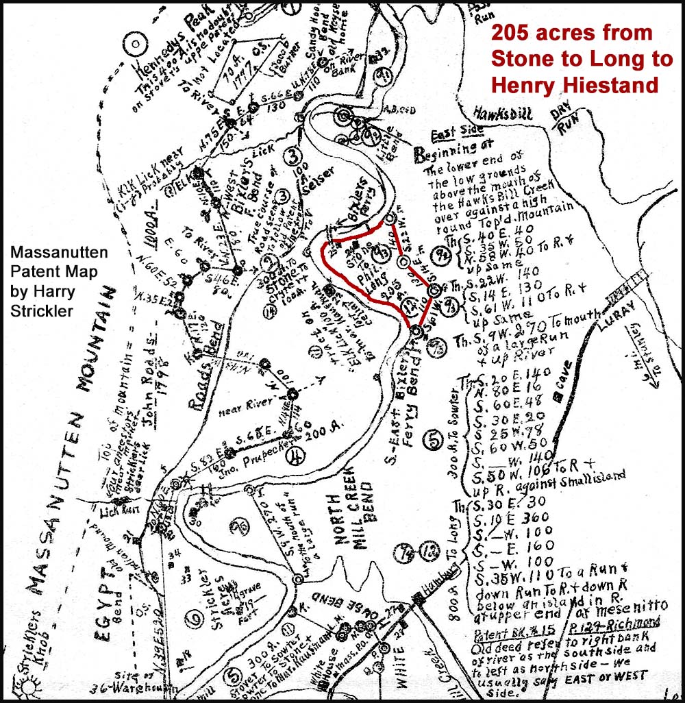
"205
Acres" - 1743 from Philip Long
Date: September 21, 1743
From: Philip Long
To: Henry Heastand
Consideration: Five shillings
Metes and bounds:
Point: Forked ash on Shenandoah River
Line: S22W; 140p;
Line: S14E; 130p;
Line: S61W; 110p;
Point: Follow river to beginning |
From Jacob
Stover to Ludwick Stone to Henry Heastand
According to
Harry M. Strickler, Jacob Stover delayed in
conveying 1000 acres of the Massanutten
patent to Ludwig Stone. But when the
conveyance was made on March 22, 1737, Stover
conveyed 1050 acres--800 acres to
Philip Long in Long Bend (near Alma, VA) and
205 acres to Long in East Bixler's Ferry
Bend (about 10 miles north of and down river
from Long Bend). But what about the
additional 45 acres that was conveyed
from Stover to Long that is not accounted for in
the 800 acres and "205" acres tracts?
Original Sources:
-
Granted to
Ludewick (Ludwick) Stone from Jacob Stover:
November 24, 1737 in Orange County, VA Deed
Book 1, page 190.
-
Granted to
Philip Long from Stone: Recorded on
March 22, 1737 (or 1738) in Orange County,
VA Deed Book 2, pages 260-261.
Source:
Pages 34 & 121 & 129-131 of Massanutten:
Settled by the Pennsylvania Pilgrim 1726 by
Harry M. Strickler (originally published in 1924
and now published by Literary Licensing, LLC.) |
264 Acres Tract - 1762
Page 6 of
Frederick County, VA
Deed Book MWhen he
metes and bounds calls are plotted for this
survey, the configuration and size appear as
they do on the image above. But it is
apparent that this 1762 "264 acres" tract is
smaller than the 1743 "205 acres" tract.
As noted above, it appears that the 1743 tract
actually contained more than 300 acres.
So, the 1743 tract would be larger than the 1762
tract, if indeed the 1762 tract only contained
264 acres.
But when Henry Hiestand
transferred his South Fork Shenandoah River land
to three of his sons (Jacob, John, & Peter) in
March of 1777, the total amount of land
transferred was 792 acres.
232 acres to John
230 acres to Peter
330 acres to Jacob
792 total
So, how do we account for this
discrepancy? Even if the 1734-purchased
land contained 310 acres, where did the
additional approximately 482 acres come from, if
the 1762-purchased tract only contained 264
acres? There are at least two
possibilities:
- The 1762 tract survey is
vastly inaccurate and it actually contained
nearly 500 acres, rather than 264.
Perhaps this 1762 tract was much larger than
264 acres and it extended back to what is
now Route 654.
- Henry acquired
additional adjacent land at some point, for
which we have no record of the acquisition.
Download
page 6.
|
"264 Acres" - 1762 from Lord Fairfax
Date: August 2, 1762
From: Thomas Lord Fairfax
To: Henry Hestant
Metes and bounds
Point: Forked ash and butterwood on south of
river - corner of
Massanutten tract
Line: S12E; 24p; along line of marked trees
Point: white oak and red oak corner to John
Bumgarner
Line: S30E; 140p; with his lines
Point: his corner two pines
Line: N60E; 60p; with another of his lines
Point: pine in his line
Line: S6E; 70p;
Point: pine
Line: S30W; 240p;
Point: large pine
Line: N60W; 142p;
Point: line of old
Massanutten Tract
Line: N61E; 110p; with
lines of said tract
!
Strickler map says 110 poles - which seems to be
correct according to the original metes and
bounds for the Jacob Stover 5000 acres
Massanutten tract.
! Deed says 34 poles
Point:
Line: N14W; 130p;
Point:
Line: N22E; 140p;
!
Strickler map says 140 poles - which seems to be
correct as per the 5000 acres Massanutten tract
survey.
! Deed says 160 poles
|
|
|
Thoughts Regarding the Values/Costs of
Henry's Lands in
Lancaster County, PA and Orange
County*, VA in 1737-1743
*Would eventually become part of Page County
Note:
Philip Long
paid 100 pounds (2,000 shillings) for 800 acres
[near Alma, VA on the South Fork Shenandoah River] +
205 acres [land Henry purchased from him,
also on the same river] in 1737 or 1738 in Orange
County, VA.
-
Compare the amount
that Henry paid for the 205 acres in Virginia to the
35 pounds
and six pence [6 pence = 1/2 shilling] that John
Coffman paid for the 226 acres in Lancaster County
in 1743.
-
Why would Henry have
paid 20 pounds more for 21 fewer acres in Virginia
than his 226 acres in Pennsylvania was worth -
especially since Lancaster County land was in
greater demand at the time?
-
Maybe it had
something to do with the fact that the
205 acres tract in Virginia has approximately 1.8
miles of frontage on the South Fork of the
Shenandoah River, whereas the 226 acres in Lancaster
only had a small stream (or "run") running across
its southwest corner.
Deed for the 205
acres in Virginia - download
pages 417-418 and
pages 419-420.
Orange County, VA Deed Book 7, Pages 417-418 and
419-420.
Document on pages 417-418 gives the price of
5 shillings, apparently per acre.
Document on pages 419-420 gives the price of 54 pounds,
16 shillings, and 6 pence, apparently total price.
|
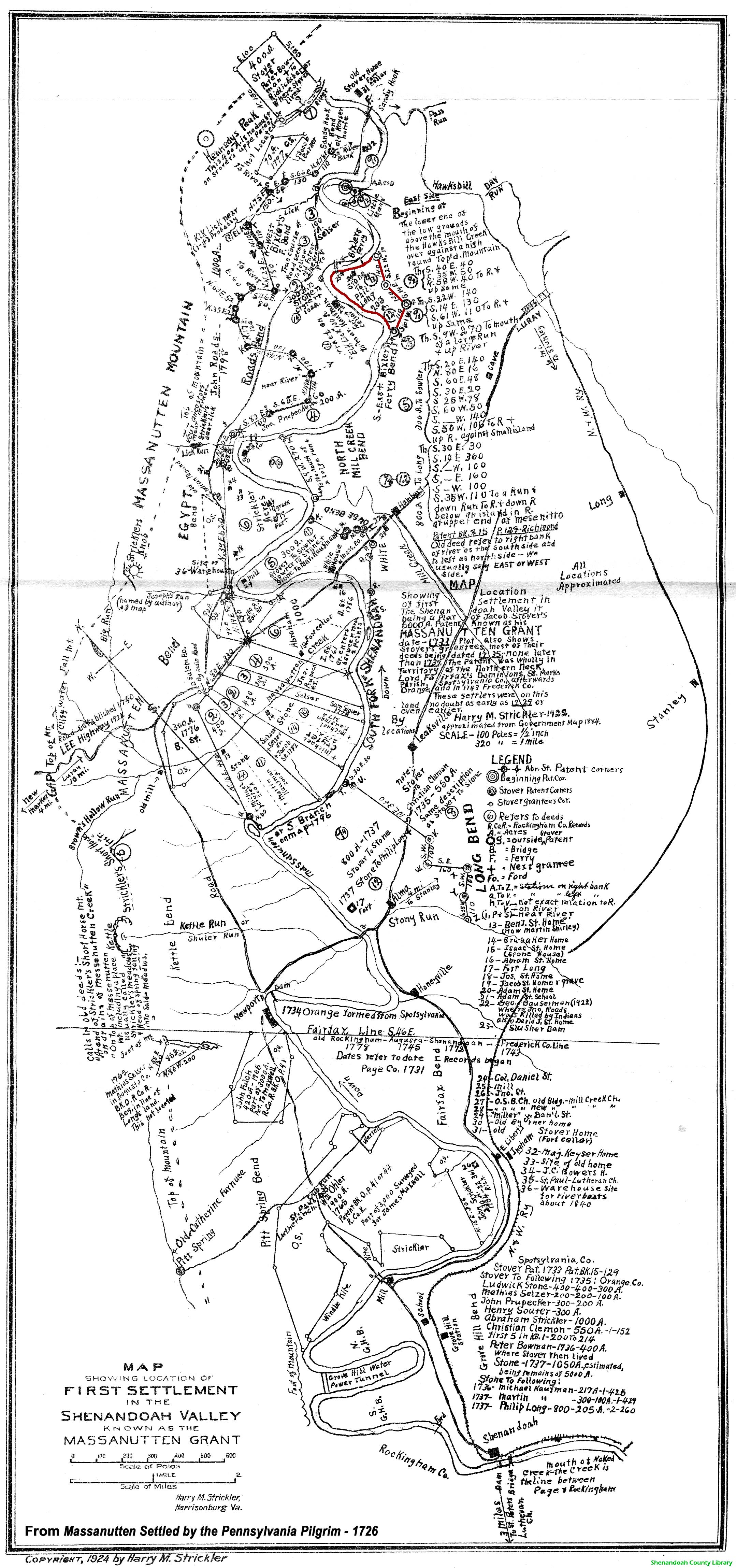
Massanutten (Jacob Stover) Patent Map
Created by Harry Strickler
(approximately 1924)
Download Full Size Massanutten Patent Map - 16" x 7.5
" (1.31 MB)
|

