| Mead & Debards Mill - See
Shells Ford Mill. |
| |
| Miller's, (Wiley) Mill on
Laurel Creek in a deed of 1865. |
| |
|
Mitchell's Mill on Caney Fork up river from the Butt's
Ford and bridge, was built in 1865. |
A grist mill and sash were operated by
Mitchell. The mills gave employment to 30 to 40 men.
A small community grew up near the mill. In 1923 there
was no trace of any of the buildings.
|
|
Mitchell, (Jabez G.) Mill Dam
was located "150 poles above Burdens Branch" on the Calfkiller
River. |
This would be a little less than 1/2 mile.
This is mentioned in Grant No. 7961 given in 1828. A
deed of 1841 refers to "The old mill and mouth of Spring
Branch." The mill may have been on the Spring Branch
rather than the main river. The mill dam had been
built prior to 1827. The property was sold to Thomas
Burrough and Joseph in 1863 including the mill.
Taylor's Mill tract was sold to F.P. Austin in 1894 and
included the grist mill, saw mill and tan yard. The
first mills were probably on the left bank of the Calfkiller
River.
For the further use of at least a part of
this property see "Burroughs
& Taylor Factory" on a previous page.
|
| Mormon
Mill on Caney Fork River was located about 1/4 miles
above the mouth of Cane |
Creek. It was first known as
Scarbrough Mill and began operations between 1810 and 1812
according to Goodspeed's History. According to Jim
Baker he first structure was a "wing dam" which diverted the
water or the amount needed to the "water-house." The
mill operated on a low head of water. Next a man named
Carnes, from Michigan came in and built a rock dam using the
thin flat rocks from the river bed. When he had
finished he said, "Now I've got the old Caney Fork
collared." It was not long before a big spruce pine
came down the river on a flood tide and tore down the rock
dam. Mr. Baker went on to say that the first real
timber dam was built by a man named Goodman, who built a
number of dams on the Caney fork and other streams.
Jim Baker said that when he was a small boy he knew and
talked to Mr. Goodman, who was then a very old man.
John Dale built or had built a dam between
1831 and 1839. He was probably the owner and this may
be the dam that Goodman built. James Anderson became
owner of the property and he sold it to John Warren in 1849.
A deed of 1848 and the one of 1849 included "mill and
distillery conveyed on Caney Fork in Hickory Valley."
The mill was sold again in 1872 when A.S. Rogers sold to
Dyer White and for a time the mill was called the Dyer White
mill. The property went to John Mosley who sold it to
C.E. Mormon in 1894. This accounts for the name
"Mormons Mill."
The dam and mill were washed out in the
flood of March 1902. A few traces of the mill were
still visible in 1923 but are now under water unless he
reservoir level is very low.
|
| Nelson's Iron Forge -
See Iron Forge Rocky
River. |
| |
| Ogden Mill - See listing
under
Carding Mills. |
| |
| Phifer Mill - See
Reno Mill on Caney Fork River. |
| |
| Pitt's
Bottom - Iron furnace and charcoal. Traveling east
toward Rock Island the Pitt's Bottom was |
located to the left of the road
after passing the Squire Hash home. It was up a hollow
and in back of the Friendship Church. The charcoal was
made to use in the manufacture of gun powder. The
operations were carried on by either Pitts or Amsterdam or
both men. Very little information was very limited and
it appeared to the writer in 1925 that the operations were
all prior to the Civil War.
|
|
Rock Island Mill - This mill was built at the lower end
of the Island by John Goldson, father of |
Wiley Goldson, for John B.
Rodgers after he acquired the property. Old Dr. Mason
of Quebeck told the writer that Goldson took the job with
the understanding that he be paid part in cash and take the
balance from the operating profits till paid. He did
not receive any cash payment. During the War Goldson
operated the mill while Rodgers was in the north.
James McGiboney said he remembers going to the mill as a
young boy. He said a dam about 8 feet high was built
across the lower end of the slough. The slough
gradually filled with mud, the property was neglected and as
Dr. Mason said the mill did not operate after the close of
the War.
|
| Reno Mill
on the right side of Caney Fork River a few hundred feet down
stream from the present Reno Bridge. It was almost due
southeast of the Onward Community. Spring water flowed out
of a cave behind an over-hanging bluff. The water was
carried to a large over-shot wheel. The mill buildings
were gone by 1923 but the over-shot wheel did not disappear
until about 1925. Albert Kuhn owned the property at that
time. The original land grant at Reno
was to Elijah Hill. According to older citizens visited in
1924 there was a mill operating at this location prior to 1822.
In 1841 John E. Turner was operating a saw mill, powder mill and
probably a grist mill. Turner also operated a "large
plantation." E.J. Reno was the owner of the mill site in
1912. See
page 50
[of the book]
also.
Source of Reno Spring Water
| In October 1927 the writer made a
study of some underground stream flows from a stream
that dropped into several sink holes at the foot of
Gum Spring Mountain and 5 miles north of Reno
Spring. A green dye was used to color the
water entering the sink holes. It reappeared.
Colored water appeared at 2 springs on Calfkiller
River, one 2 1/2 miles southeast of the sink holes
and one 3 1/2 miles south east.
Much to our surprise the color showed
up in a well at Onward, 4 1/2 miles south of the
sink holes, at an underground stream, in a cave a
half mile further south at Reno Spring another half
mile south on the Caney Fork. The farmer found
out that his fine, cool well water came for the
run-off on the side of Gum Spring Mountain. It
did not worry him. |
Webmaster's note:
This spring that sank near Gum Spring Mountain, was probably
the one known as
"Sinking Creek." In the early 1800s there was a Primitive
Baptist Church at that location by the name of
Sinking Creek Baptist Church.
|
| Ross Mill on the right
bank of the Caney Fork. - See
Underwood Mill. |
| |
| Rhodes, James, Mill
Branch mentioned in 1851 deed on the right bank of the Caney
Fork below |
Franks Ferry. There must have
been a mill there at some time.
|
| Rice, T.B. - See
Harriet Iron
Works. |
| |
| Savage, George, Mill.
This was an early grist mill on the Barren Fork upstream from
McMinnville. |
| |
| Savage, George - A later
generation than one above. - See
Brady Haston
Mill. |
| |
| Scarborough Mill on Caney
Fork. See
Williams Mill. |
| |
| Scoggin Mill on Caney
Fork. See
Williams Mill. |
| |
|
Shell's Grist Mill on Collins River at Shell's ford and
frequently referred to as Shellsford Mill. |
It was operated by James Shell. The
mill was built in 1869 by E.G. Mead. A deed of 1886
mentions both the mill and ford. In 1887 Mead and
Debard were operating a grist mill, saw mill, planing mill,
flour mill and grist mill at this location. A deed of
1903 refers to the "Chastian
Mill."
|
| Sims, William, operated a
corn mill below Wilhites on
Cherry Creek. |
| |
| Simmon's, James, grist mill
on Cane Creek mentioned in deed from James Simmons to Robert
|
Gamble. From a deed made in 1882 the
grist mill was about 9,000 feet as the crow flies upstream
from Carter Drakes Lime Kiln which had been burned.
There is a further reference to "the upper Drake place."
|
|
Simpson's Mill on the Calfkiller River about 4 miles
below Sparta. Goodspeed p. 799 states that |
"Thomas Simpson settled on
Calfkiller River, four miles below Sparta, and Joseph Terry
at Rock Island on Caney Fork, now in Warren County, at about
the same time." Terry was at Rock Island prior to
1807. The Carthage Gazette in the March 19, 1814 issue
stated that "Simpson's Mill was operating on the Rocky
River." This statement was incorrect and it should
have read "Calfkiller River."
Grant 3399 Entered July 20, 1821 (or 1831,
not clear) refers to James Simpson's (deceased) place which,
according to the description, was up the river from Simpson
Mill. The mill was located on Simpson's original grant
for 100 acres. There was a saw mill and grist mill and
dam in the original layout. James Williams (1785-1876)
helped saw out the lumber for the mill and covered bridge.
This bridge was the main crossing for travel on the Sparta -
McMinnville road. John W. Simpson's name entered the
picture at an early date. The John W. Simpson Mills
added 20 acres in 1825, 50 acres in 1826 and 75 acres in
1849. The latter "adjoins the old 100 acres on which
the mills are located." Reference is also made to "the
saw mill under the bluff on the east side of the river.
During August 1862 there was a fight at
Simpson's Mill between Col. Whorton's Texans and General
Nelson's Federals in an 1851 deed to J.W. Simpson's heirs.
In 1871 and 1872 the properties were transferred to O.F.
Young* and from that time were referred to as Young's Mill.
During this period there are references to both a corn and
flour mill. The mills were sold to the Hill family in
1898 and in 1902 to the Farmers Flouring Mill & Elevator Co.
which was granted a charter by the White County Court in
1900 with a capital stock of $10,000 and increased to
$30,000 in 1902. The deed of 1902 refers to an old
store and an old still house. The properties were
deeded to R.L. Hill in 1911. 200 acres were deeded to
White County in 1906 for the White County Poor Farm.
*Note - O.F. refers to Oliver F. Young.
John W. Simpson and the
War of 1812
| The following is from
Goodspeeds History p. 805-06. "When the
War Department made a requisition on the State
of Tennessee for 2,500 men to serve in the War
of 1812, White County contributed two full
companies, which were commanded by Capts. John
W. Simpson and George W. Gibbs. Capt.
Simpson was promoted to the rank of Lieutenant
Colonel and distinguished himself for bravery at
the Battle of New Orleans." |
|
| |
| Smallman & Swan - See
Bailiff Mill. |
| |
|
Sparkman's Mill on Cane Creek in the first sharp bend
above the mouth of the river. |
The dam was 6 feet and 5 inches high.
The mill building was on the left bank. There was a
foot bridge 200 feet above the dam in 1912. In 1923 a
few of the dam timbers were visible.
Sparkman received the land by deed in 1909.
This mill was on property that probably belonged to Carter
Drake. The writer did not have enough information to
identify it for sure.
|
|
Sperry,
Thomas & Lane, Jacob A. Mill was located on Town Creek,
about 2 miles above |
Sparta. At first there was a corn
mill. ____ Givens was the operator at one
period. It was referred to in deeds of 1854 and 1881.
It was later operated by Allen & Mayberry and then to the
Tubb family. At one time there was a saw mill and
powder mill at this site. There was also a tailor shop
and Saloon adjacent to the mill.
|
| Swindle, Clark, Sr. -
operated a grist mill at an early date on Cedar Cr. Later
it was called Swindle & |
Sanders corn and saw mill.
|
| Tailor Shop - See
Sperry & Lane
Mill. |
| |
| Tosh Mill
was located on the right bank of Caney Fork a few feet upstream
from Tosh Bridge and |
old ferry site. The first mill was
in a cave and powered by water from a spring branch.
The property was sold to Ed. Blankenship in 1884. He
built a flume from the cave to a new building. It is
of interest to note that the Blankenship property was at one
time a part of Van Buren County. This was the result
of an Act of the Legislature of 1869. It was later
transferred back to White County. The story is told
that at one time a pond, some distance away sank and drained
out through a sink hole and that many frogs came out at the
mill spring branch. The property was in the name of
Wiley Goldstone when first surveyed for the Great Falls development.
|
| Turner, John E. - Powder
mill - See Reno Mill. |
| |
|
Underwood Mill - This mill was located in a large cave
on the right bank of the Caney |
Fork River about half way between Tosh
Mill and Reno Mill. As the writer remembers it the
cave was large with a high overhanging bluff. The
water came from an underground stream that flowed out of the
cave. There were no remains of the mill in 1923. There
was one reference to the Underground Mill in a land
description in 1848. The property originally belonged
to the Ross Family. According to tradition they built
the first mill.
|
| Van Buren Land Co. Saw Mill
- They began operations on the Caney Fork in 1902. Their
operations
|
were not destroyed by the
1902 flood. They had a log boom from Mitchell's Ford
downstream to the Mill. It appears that they took over
the Mitchell Mill.
|
|
Wallace, S.D. &
Cooper, Wm. Saw Mill and Grist Mill - The White County
Court at a meeting in |
January 1882 gave Wallace &
Cooper the right to build a dam on Caney Fork at Molloy
Shoals above the Porter Ford and to erect a saw and grist
mill. This was in the second district of White County.
A grant of 1829 refers to an old mill dam built by John
Porter. This was at Butts ford or upstream from it.
|
|
Walling Mill Co. mill on
Mountain Cr. was located about 1/4 mile above the mouth of the
creek. |
It was also referred to as
the J. Walling Mill. The dam, 10 feet high, was built
of logs. An unusual feature was a flume about 100 feet
long, extending down stream to a wheel pit in which a water
turbine with a vertical shaft was mounted. By use of
gears a horizontal shaft extended some 50 feet to a 2-story
mill building. An old store building was also located
on the property.
All of the above information was taken
from the Bylessby drawings made from the 1912 surveys.
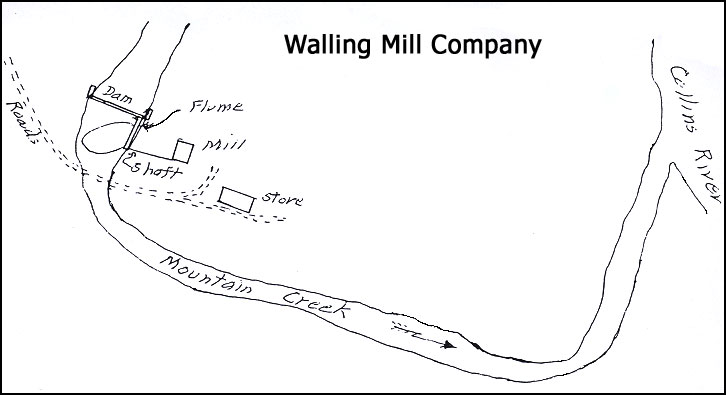
Originally the Mill was owned by Walling,
W.C. Womack and Alice Jones. A deed of 1898 refers to
"the mill property." Jesse Walling apparently became
the sole owner at that time
|
| Walling, James - See
Laurelburg Mill. |
| |
| Ward, H.R. - See
Brickford's Mill. |
| |
| Warren's Saw Mill - See
Brady & Haston
Mill. |
| |
| White's Mill pond - See
Dale & White's
Mill pond. |
| |
| White, Dire (Dyer?) in 1865
built a mill and had a sash saw operating in connection with it
on Caney Fork. |
- See Mitchell
Mill.
|
| White, Dyer - See
Mormon Mill. |
| |
|
Wilhite Corn Mill was located on Cherry Creek. |
| |
| Wilkinson's Mill on
Collins River. Notes are incomplete. Appears to have
been near Gribble Ford and |
may have been on a small branch.
|
|
Williams
corn, flour and saw mills were located on the north bank
of the Caney Fork above the Scoggins |
Shoals and about a mile below River Hill
and the mouth of Cane Creek. The Williams farm was in
the lower end of Hickory Valley and extended along the Caney
Fork for nearly 1/2 mile.
The property first belonged to the Scoggin
Family. John Scoggins received 144 acres under Grant
No. 534 on Caney Fork River near a Spring Branch in 1808.
In 1809 John Scoggin transferred to Jesse Scoggins 64 acres,
a part of grant 534. (Bk. B, p. 113-16) In 1816
John Scoggin deeded an additional 21 acres to Jesse Scoggin.
(Bk. F, p. 36) Jesse Scoggins received 23 acres on
Caney Fork River near a Spring Branch by Grant No. 10809.
Jesse Scoggins had the first Mills built.
In addition to operating the mills and his farm he was a
brandy distiller.
According to Jim Baker the dam was built
by Mr. Goodman, an experienced builder of dams and the
builder of many dams on the Caney Fork. Several of the
children of Dan Rogers, Mr. Goodman's son-in-law, were
living in Doyle in the 1920's. Jim Baker said Goodman
was a very old man when he was a young boy.
The dam was built largely of white oak
timbers hewn and mortised in the woods. It was floored
with hewn or sawed planks. Jim was by the mill in 1892
and said that the dam was "partially rotted out and washed
out at the time."
|
| Womack, W.C.
- See Walling Mill Company. |
| |
|
Woodman Cotton Mills were
located on the right bank of Barren Fork River in McMinnville on
the |
property where the Annis Cotton Mill was
later built. The mill was also referred to as the
McMinnville Manufacturing Co. The property was sold to
Asa Faulkner. Deeds of 1866-67 refer to "old mills,
debris dam, etc." Another deed refers to "Woodman Mills
being on the land sold to Faulkner." According to an
affidavit of W.A. Bell the first mill in the area was the
Woodman Cotton Mill. He further stated that it burned
soon after the War.
Asa Faulkner bought the right of way along
the right bank of Barren Fork for a canal to carry water
from the upper diversion dam down to the mills below the
railroad bridge. This purchase was made in March 1860
by Goodpasture who also sold some additional land for the
cotton factory. In 1859 John B. French, A.P. Welcher
and Berry Layne sold Asa Faulkner additional canal rights
and the right to build a dam.
After the War Faulkner built the Annis
Cotton Mill. Asa Faulkner and his son W.P. Faulkner
bought water rights for a dam to be built below the railroad
bridge. The dam had been built in 1880.
Jesse Walling purchased the Anis Cotton
Mill properties in 1903 and the same were transferred to the
Walling Light and Power Company in 1903. For further
developments in this area see "McMinnville Hydro Electric
Plant" under the general heading "Electric Power Plants."
|
| Young's Mill on
Calfkiller River - See Simpson's Mill. |
| |
| York's
Mill on Laurel creek - York received a grant in 1838,
Entered 1834 to lands on Laurel Creek |
and Rocky River. A deed of 1860
refers to York's Grist Mill. A deed in 1883 refers to
the above property as "Mrs.
Passons Mill."
|