|
Falcon Flour Mill on Barren Fork immediately down stream
from the Railroad Bridge was |
built on land purchased by Asa Faulkner in
1880. He sold a one-half interest to Jesse Walling in
1885 and the remainder in 1887. After that date it was
called the Falcon Roller Mill. One source states that
the first mill was established in 1879.
|
|
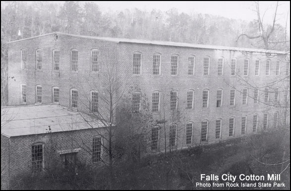
Falls City Cotton Mill
- The story in this section is really the second chapter in the
|
development of power at Great Falls.
Asa Faulkner purchased the property
formerly belonging to the Cunningham family in 1881.
This included most of the land between the Caney Fork and
Collins River. In 1883 he bought a one-half interest
in the Bosson property across Caney Fork. He, together
with Clay Faulkner, Jesse Walling and H.L Walling had a
wheel pit dug and a low diversion dam built at the Falls.
James McGiboney installed a saw mill and grist mill for the
owners and was employed to operate it. The owners
erected a timber bridge across the mouth of Collins river
and a log toll house on the hill above the saws mill.
Later a frame house was erected on the river side of the
road closer to the bridge. This house was erected on
the river side of the road closer to the bridge. This
building was used as a construction office during the
building of the power dam. It was torn down in 1927.
Mr. McGiboney sawed out all the timbers and lumber for the
bridge and houses.
A small community grew up in the area and
was called "Falls City." The Spring of 1892 saw the
first real boom for Falls City. The Falls City Cotton
Mill Company was chartered with a capital of $30,000 to
"manufacture, spin, weave, bleach, dye, print, finish and
sell all goods of every kind made of wool and cotton."
A three story brick mill was erected by the Company.
The brick were burned on the hill and a short distance
upstream from the mill. The Company also purchase the
toll bridge from Asa Faulkner.
The Mill was heavy for its "Heavy
sheeting." There was a Post Office, store and other
structures at Falls City although all are gone. The
mill furnished employment to citizens of the neighborhood
and the little community thrived and grew. Then came
that memorable Good Friday in March 1902 when the heavens
opened up and rain came down in torrents. The mighty Caney
Fork, like a dog which had been straining at it's leash,
suddenly broke loose. The raging torrent sweeping down
off the mountains carrying death and destruction before it
swept away the wheel house and the Collins River Bridge as
well as every other mill on the river. The old river
had gained one more victory over man thus ending the second
chapter in the development of power at Great Falls.
Easter Sunday in 1902 was a lovely clear day but for the
citizens of Falls City things looked very gloomy even though
they knew in their hearts that the old river would some day
be conquered.
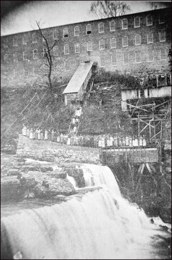
Falls City Cotton Mill
| This mill, sometimes referred
to as the Great Falls Cotton Mill, was located
at the Great Falls of the Caney Fork River.
Heavy cotton sheeting was the best known
product.
[Note:
This photo was not in Mr. Crouch's book.]
The original
wood block used to stamp the sheeting, using
powdered bluing was found in a trash heap under
the mill by the writer about 1928 and was given
to the McMinnville Public Library. The
sketch below was taken from an old envelope.
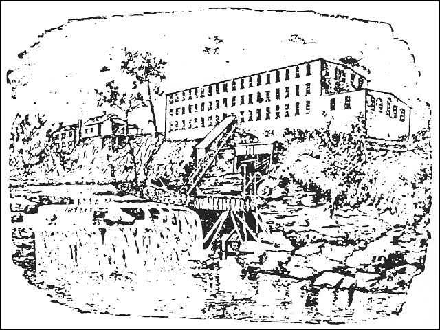
Part of the
flowing water was diverted towards the river
bank and into a channel behind the stone wall.
The water then flowed into the wood flume which
carried it into a recess cut in the bluff.
It then flowed into the water chamber in which a
turbine was mounted. The turbine shaft
extended up into the horizontal shed above.
A rope pulley connected the turbine shaft with
another under the sloping roof. Again a
rope belt was used to connect with the main
drive shaft in the mill. Power was
transferred to various parts of the building
with belts and shafts.
Fall City Post
Office was located in one of the buildings to
the east of the Mill. |
|
| Faulkner, Asa - Erected a
cotton mill on Charles Creek in 1846. It operated till the
War after |
which it was converted to a cotton gin.
This may be the same as the Central Factory cotton mill
built by T.H. Faulkner.
|
|
Faulkner Woolen Mills on
Charles Creek was established in 1773 [1873?] by T.H. and his
brother, |
Clay. Clay bought out his brother's
interest in 1877. It was called The Mountain City
Woolen Mill at that time. In 1887 new machinery was
installed the plant was known as the Clay Faulkner Woolen
Mill.
|
| Faulkner, Asa - See
Woodman Cotton
Mills on Barren Fork for power rights and mills at
|
McMinnville owned and built by Faulkner.
|
| Galloway's Mill on Laurel
creek, 200 feet above a foot bridge and 100 feet above the ford
|
where the Spencer Road crossed Laurel
Creek. The Dam was 7 feet high. This description
was taken from one of the H.M. Bylessby & Co. maps and
covered conditions as they were about 1910-12. J.J.
Galloway owned the mill at that time. H.C. McCoy and
Daniel Tosh owned adjacent property.
|
| Gaston's Mill Branch in
Big Bottom - See Davis Mill. |
| |
| Glenn's Grist Mill -
Goodspeed, p. 799-80 mentions that William Glenn built a grist
mill on |
Calfkiller about 1815. The writer
believes that this mill was located above the falls of the
Calfkiller and above the Harriett Iron Works and may be the
same location as the Jett Mill site. - See
Jett Mill
|
| Goodbar's Mill
on Rocky
River downstream from the concrete arch bridge on the Spencer
Road. |
A deed from Gardner & Co. to J.M. Goodbar
in 1865 mentions and includes the mill, storehouse and tan
yard. Goodbar's Mill mentioned in a deed of 1871.
Some additional land was transferred to Wm. Goodbar in 1872.
The property was sold to Geo. E. Kell in 1878, to Harmon
York and Jacob Stipes in 1880 and York's share to Stipes in
1882.
After that the following transfers were
made: to I.A. Justice 1884, to H.R. Gribble mentions grist
mill 1888, J.J. Walker 1900, A.L. Johnson 1902, Victor A.
Russell mentions Roller Mill 1906, A.L. Johnson 1909, T.F.
Page 1910 and D.T. Johnson 1910.
|
| Graham's Still House
mentioned in Big Bottom in 1843 deed. It was on the south
side of the |
river. There were a number of
orchards in that area but no signs of them in 1923 except a
few scattered trees.
|
| Gribble's Mill - See
Goodbar's Mill. |
| |
| Grizles & Wisly Wilson Grist
Mill on Barren Fork near McMinnville. |
| |
| Great Falls Saw Mill- See
Falls City Cotton Mill. |
| |
| Grissom's Mill on Laurel
Creek - See Drake's Mill. |
| |
| Harrison's Mill
Creek was a small tributary of the Calfkiller River near
Taylor's Factory. |
| |
| Hill & Savage Mill built
about 1807 was probably one of the first, if not the first mill
to be |
built in Warren County. Henry J.
Hill and Jesse Savage built the mill on Indian Village
(Hill) Creek, a tributary of Collins River.
|
|
Harriet Iron Works was located on the left bank of the
Calfkiller River about one mile down |
stream from Sparta and above the falls of
the Calfkiller River. Isaac Swindle and Armstead
Stubblefield, Ass'ee of Jesse Swindle, received 514 acres on
both sides of the river by Grant 2813 Jan. 12, 1811, Entered
Aug. 7, 1807 on N.C. warrant No. 106 dated Dec. 12, 1804.
Surveyed in 1809. This grant included the falls and
land on which a future hydroelectric plant and a cotton
mill would be built. Either both of the men or one of
them immediately built and operated the iron works.
George Matlock and Robert Allen purchased
the property at a Sheriff's sale in 1812, including the
Harriet Iron Works, land on the Calfkiller River and 50
acres on the Caney Fork River including an iron ore bank.
The project was operated for a few years
under the name "Rice & Herbert" as indicated in a deed from
Thomas Herbert, dec'd to his wife Sarah Herbert through the
County court June 10, 1817. It included the Harriet
Iron Works and a grist mill and saw mill.
The property was involved in a great deal
of litigation and property transfers during the next 40
years. An 1849 deed to John B. Rodgers refers to "the
old Harriet Iron Works" indicating that the mill was no
longer in operation. John W. Simpson received the
property in 1855 which included "the Harriet Iron Works."
A deed of 1853 refers to the Minton
Factory House which may be the Cotton Mill which operated
for a number of years prior to the Civil War. It was
located on the right bank of the river on the side of the
hill and about opposite the site of the hydroelectric
plant which was built later. During the Civil War the
machinery was moved south for safety and never returned. A
deed from John B. Rodgers to the Sparta Manufacturing Co.
gave the Company the right to repair the old bridge or build
a new one. This was located downstream from the plant.
Foundations of the cotton mill and slag heaps at the iron
works were still visible and seen by the writer in 1927.
For the further use of this property see
"Sparta Hydro Electric Plant" under the general heading
"Electric Power Plants."
|
| Hill, (J.A.) Mill - See
Simpson's Mill on Calfkiller River. |
| |
| Iron
Forge Mill - A grist mill on Rocky River located
downstream from the Iron Forge |
described in the next item. It was
owned and operated in conjunction with the Forge.
|
| Iron Forge - On the left
bank of Rocky River a short distance below the Rowland Ford,
|
sometimes referred to as the Hash Ford or
the Indian Ford. Larkin Baker received a grant entered
in 1826 for 50 acres on Rocky River. He, according to
available information was the man who built and first
operated the iron works. Thomas Mayberry sold 15 acres
including the Iron Works to James Miller in 1832 and sold 30
acres to James Miller and John Cain, including the Iron
Works in 1833. (There is an apparent duplication
here.)
*Printed note from margin: "James William
Wallington Miller, son Abrm. Miller II, Bro. Cyrus Miller."
James Miller* conveyed to John B. Rodgers
in 1835 a one-half interest in the Iron Works and 30 acres
of land on which it stood and also sold 100 acres of land
owned by Miller and 15 acres originally purchased from
Larkin Baker. He in turn conveyed the property to his
brother Dr. A.C. Rodgers in 1860. This deed calls for
"the iron works." The next deed, to Dewitt and Horace
L. Rodgers, made reference to "acres known as the Forge
tract." A man named Nelson was also a partner and was
the last man to operate the Forge. After the War the
place was usually referred to as "Nelson's Forge." One
source refers to a bridge at the above location but the fact
may be open to question. The ore was found in small
pockets in the land around Squire George H. Hash's farm.
Many excavations could still be identified in the 1920's.
It is understood that operations ceased prior to the Civil
War.
See the
Walker Story on the following page.
[that is, the following page of the
book, but in section
below of this website page, "A Man Takes His Pay in Iron
Billets"]
See
Pitt's Bottom Iron
Works also located near Rock Island.
A Man Takes His
Pay in Iron Billets
| John Jefferson Walker, Sr.,
father of the former Mayor, J.J. Walker, of
McMinnville, applied for work at the Iron Forge
during its last years of operation. John was not
much more than a boy and lived about 7 miles
from the Forge. The owners agreed to pay
him in iron instead of cash which was in short
supply. It was agreed that he could take
what he could carry, walking, each day. He
carried at least one 25 pound billet each day
and stored the iron in an old smoke house.
He would not sell any iron. He told the
family that the mill was bound to close down
soon and then there would be a demand for iron
for its many uses on the farm. The Forge
closed down and in about a year he began selling
at a very good price in small lots. He
invested his profits in excellent white oak
timber land saying he could wait a little and
then sell off the timber at a good profit.
This he did. |
|
| Jett's Mill Dam.
This mill must have been above the Harriet Iron Works.
There is a reference |
in 1812 to the Jett lands on Calfkiller
River. Jett sold to a Mr. Connor in 1830 and the Jett
Mill Shoals is mentioned. In 1884 the Jett heirs sold
"the Mill site" to S.D. Wallace. The writer was not
able to get any definite information in the late 1920's and
was of the opinion then that the mill did not operate for
any long period. See page 50 [not
sure what is being referred to on page 50, which would be
toward the bottom of the following web page].
|
|
Laurelburg Mill on Rocky River. This mill site
included a grist mill and saw mill. The mill |
buildings were on the right bank and at
one time a store was operated in connection with the mill.
Elijah Drake lived on Rocky River prior to 1826. He
probably built the mill. A grant in 1846 to Abraham
Drake, assignee of Elijah Drake Jr. mentions "a Mill tract"
and also refers to "Drake's Mill." James Walling was
the owner of the mill at the time the first surveys for the
Great Falls Project were made in 1911-12.
|
| Lost Creek Mill was
located on Lost Creek in White County and was one of the early
grist |
mills in that County. It is
mentioned in Morris' Universal Geography and was built
before 1808.
|