The Heritage of Daniel Haston


1811 Deed for Union Meeting House Property

 
1811 Union Meeting House Deed on Current Map
Original Deed on Current Map
Showing Location of the Current Meeting House

1811 Deed for Union Presbyterian Church Land
Click for Larger, Readable Deed


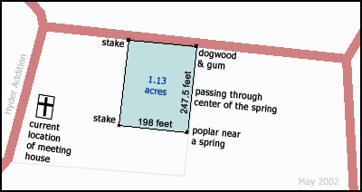
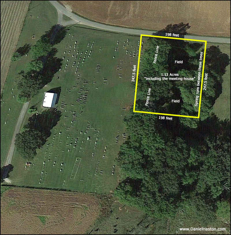
1811 Deed Compared to Current Property

When plotted on a current map that includes a location of the Union Meeting House as it stands now, the 1811 deed for the Union Meeting House, assuming that it is accurately described on the original document, clearly does not encompass the land on which the current building stands, nor does it account for much of the cemetery property around the church. 

The trustees (as of 2003 or so) for the property were not aware of any other deeds to the Union Church and Cemetery property, other than a recent deed for the "Hyder Addition" (a strip of land 50 feet wide) that is located to the west of the road that runs along side of the church building.  This raises two interesting questions:

  • Was the original church building located where the current building now stands?  According to J.M. Passons, there was an earlier building than the current one that was destroyed by fire at some point in time.  According to the Coral Williams thesis*, the original building was "a log house was erected and put down near the forks of the road."  If "near the forks of the road" meant the intersection of the roads that now run in front of and beside the current church building, then the 1811 deed would not have included that spot.
  • When, and from whom, did the church and cemetery acquire the additional land that does encompass the current church building and the cemetery?

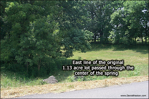
Compare the map above with the way late twentieth century cartographers (Old Union Area Topo Map) have viewed the Union Church and Cemetery property.  Except for the Hyder Addition, which was not a part of the Union Cemetery when this map was created, this relatively recent topographical map is a fair representation of the way the church and cemetery property "appears" today.  Notice that the cemetery does not extend eastward all the way down to the spring, the low and wooded area several feet east of the current cemetery fence-line boundary.

*Source:  Legends and Stories of White County, Tennessee by Coral Williams, 1930, her master's thesis for George Peabody College for Teachers.


Was the 1811 Survey Inaccurate
or did Spencer Mitchell Donate or Sell More Land Later ?
 

The April 15, 1808 certificate of survey (see right) for Spence Mitchell's 150 acres seems to allow for the location of the Union Church as we know it, rather than the way the 1811 deed would seem indicate it to be.  The northwest corner of Spence Mitchell's land, according to the 1808 survey, would appear to fit the location of the Union Church building and cemetery property. 

Perhaps the survey data on the 1811 deed was inaccurate, thus allowing for a plot of land larger than 1.13 acres.  But probably more likely, the original 1.13 acres survey was accurate but Spencer later donated the additional land that now includes the cemetery and church building.  If so, there seems to be no record of the transfer of the additional land.

Click below to see a larger version of the 1808 survey on a current map.


Page 360 of White County, TN Deed Book Volume F

Notes:  A rod (same as a perch) = 16.5 feet;  160 square perches to one acre

Transcription 

This Indenture made this twenty fourth day of August in this year of our Lord one thousand eight hundred and eleven, Between Spence Mitchell of the county of White and State of Tennessee of the one part, and the ministers and people of the congregation of the Union Meeting house, in the county aforesaid, and all other of God's people, who make an open profession of the Christian Religion, and are of good standing in their own Churches; (Shakers and others whose doctrine do not accord with the Gospel of peace excepted) of the other part witneseth [sic]: that the aforesaid Spence Mitchell, for and in consideration of the love good will and ardent desire, which he hath and doth bear towards the spread and, free circulation of the gospel in the land, but more particularly in his own neighborhood , hath given, granted, and transfered [sic], and by these presents Doth freely give, grant and transfer, unto the aforesaid ministers and people for the time being, and their successors forever, one certain tract of land containing one hundred and eighty square perches, for the sole and express use purpose of keeping upholding, and supporting a constant house for the preaching of the gospel, and for the further use of the tuition of youth if therefore requested; -- situate lying and being in White County on Caney Fork; in Hickory Valley; and bounded as followeth to wit:  Beginning at a poplar near a spring, running thence north passing through the centre of said spring, fifteen poles to a dogwood and gum; thence west twelve poles to a stake, thence south fifteen poles to a stake; thence east twelve poles, including Union Meeting house, and the one half of the aforesaid spring to the place of beginning, it being part of Grant No. 1621 issued by the State of Tennessee to the aforesaid Spence Mitchell; together with the appurtenances thereunto belonging or in any wise appertaining To have and to hold, the aforesaid tract of land, with its appurtenances to the proper use and belief(?) of the aforesaid ministers and people, and their successors forever, without any manner of consideration, and the aforesaid Spence Mitchell for himself, his heirs or executors, the right title interest and claim of the aforesaid land with its appurtenances, unto the aforesaid ministers and people, and their successor forever will warrant and forever defend, for the above named purposes against the claim or demand of him the aforesaid Spence Mitchell his heirs or executors, and from all manner of person or persons claiming or to claim under him or them or either of them, but against any other claim or claims will not warrant or defend.  In Testimony whereby he the aforesaid Spence Mitchell his hand and seal hath herein to subscribe and set the day and year first above written

Signed sealed and acknowledged                                          Spence Mitchell (seal)
in presence of us
Turner Lane
Jacob A. Lane

        State of Tennessee    July Sessions A.D. 1819 -- The due execution of
        White County            the written Deed of conveyance was this day was 
was acknowledged in open court by Spence Mitchell for the purposes and things therein mentioned, and ordered to be recorded -- let it be registered, given at office the 19th July A.D. 1819

Registered and Examined this 29th            __ Jacob A. Lane Clerk (seal)
September A.D. 1819                               of White County Court
              __ Turner Lane Register                By his Deputy AB Lane
                    of White County