| Annals of Tennessee,
The - 1967 Reprint
- J.G.M. Ramsey |
| |
| Critical and
Analytical Index and Genealogical Guide to Ramsey's Annals
of Tennessee |
by Fain - 1920.
(This can be of great value to those who own originals
of the book which do not have the Index.)
|
| Civil and Political
History of the State of Tennessee, The
- 1969 Reprint - John Haywood |
| |
| Cumberland, The Story
of a Name - 1903 -
John M. Gault |
| |
| Indian Trails
- by Myer - 1928.
(Page 727 of the 42nd. Annual Report of the Bureau of
|
American Ethnology
contains a comprehensive list and description of
Indian trails, mounds, towns, etc. and maps.)
|
| Natural and Aboriginal
History of Tennessee
- 1959 Reprint - John Haywood |
| |
| Tennessee, History of
- 1903 - Garrett
and Goodpasture |
| |
| Tennessee Gazetteer,
The, or Topographical Dictionary.
1971 Reprint of the original |
1834 book by Eastin
Morris. (This is a wonderful source book for Tennessee
as it was in 1834. Very easy to use.)
|
| Tennessee, History of
- 1886 - by
Goodspeed.
(This edition contains local histories for |
Cannon, Coffee,
DeKalb, Warren, and White Counties.)
|
| Resources of Tennessee
- 1874 - J.B.
Killebrew - 1st. and 2nd. Reports of the Bureau of
|
Agriculture of
Tennessee
|
| Steamboatin on the
Cumberland - 1961
Byrd Douglas.
(Covers boats, landings and men on |
the Caney Fork
River.)
|
|
Technical Information Relating to
the Caney Fork |
| |
| Bench Marks on the
Caney Fork River and Tributaries
- 1928 & 1930 - U.S.
Engineers |
Office, Nashville.
(Place names and
mileage figures are of interest to the local historian.)
|
| Stream Flow Records
- U.S. Geological
Survey: |
Caney Fork River,
1915-1932
Collins River, 1924-1932
|
| Smaller Undeveloped
Water Powers of Tennessee, A Study of Some of the
- 1923 - |
J.A. Switzer -
Division of Geology, Tennessee, Bulletin 30
|
| Surface Waters of
Tennessee - 1931 -
Warren R. King - Division of Geology of Tennessee |
| |
| Water Resources of
Tennessee - 1925 -
Warren R. King - Division of Geology, |
Tennessee, Bulletin
34
|
|
Local Histories |
| |
|
Beersheba Springs and
Chickamauga Trace, Sketch of
- by Blanche Spurlock Bentley |
of McMinnville.
(A pamphlet
published prior to 1923)
|
| Blue Springs Baptist
Church, Records of - Viola, Tennessee - 1807-1858. |
(Church was located on
the left bank of Hickory Creek in the village of Viola,
Warren County. Contains names of early settlers.)
|
| Doyle Institute
Catalog - 1925-26.
(At Doyle in White County not far from the Calfkiller
|
River. It was
typical of the many early boarding and day schools.)
|
| Warren County, Early
History of - 1930 - by Will T. Hale.
(This is a very brief history. |
It makes good
reading, but some of the statements are open to
question.)
|
| McMinnville (Warren
County) at a Milestone
- 1960 - by Walter Womack. |
(150th Anniversary of
the City. Contains a world of accurate information on
government, people, places, mills and industry, schools,
etc. Mr. Womack did a large amount of research prior to
writing the book. An index would have added materially
to the value of the book.)
|
| Mt. Zion, History of
Methodist Episcopal Church, South - 1809-1930
- by Louise Biles Hill. |
(Located in the Hickory
Creek area east of Viola. Valuable for names of early
settlers and local
history.)
|
| One Hundred years in
the Cumberland Mountains along the Continental Line
- 1933 - |
by Albert Ross
Hogue. (Most unusual 87 page book covering Indian
trails and individuals and treaties, early settlers in
Fentress and Overton Counties, Fentress County history,
etc., Soldiers of the Continental Line for 7 counties,
War of 1812 and Civil War, names and location of early
settlers and land
grants registered in Sullivan County are included and an
alphabetical list of land grants in Fentress County.)
|
| Thaxton Reunion, The -
And A Brief Sketch of the Thaxton Family of Warren County, |
Tennessee
- 1937 - by W.G. McDonough.
(This family settled in the Mt. Zion area in the western
part of Warren County in the area
drained by Hickory
Creek.)
|
| History of White
County - 1935 - by
Rev. Monroe Seals.
(The book contains a wealth
of |
information arranged in
7 chapters. It does not have an index, and lists of
people are in random order. The result is that the
reader must do a lot of reading
for a few names or
facts.)
|
| Williams, James Tate,
His Family and Recollections
- 1938 - by Joseph Vincent
Williams. |
(A well written
family book with excellent photos, paper and printing -
all housed in a beautiful binding. The Williams family
settled in White County and lived in Hickory Valley
close to the Caney Fork at one time.)
|
|
U.S. Geological Survey
Maps |
| |
|
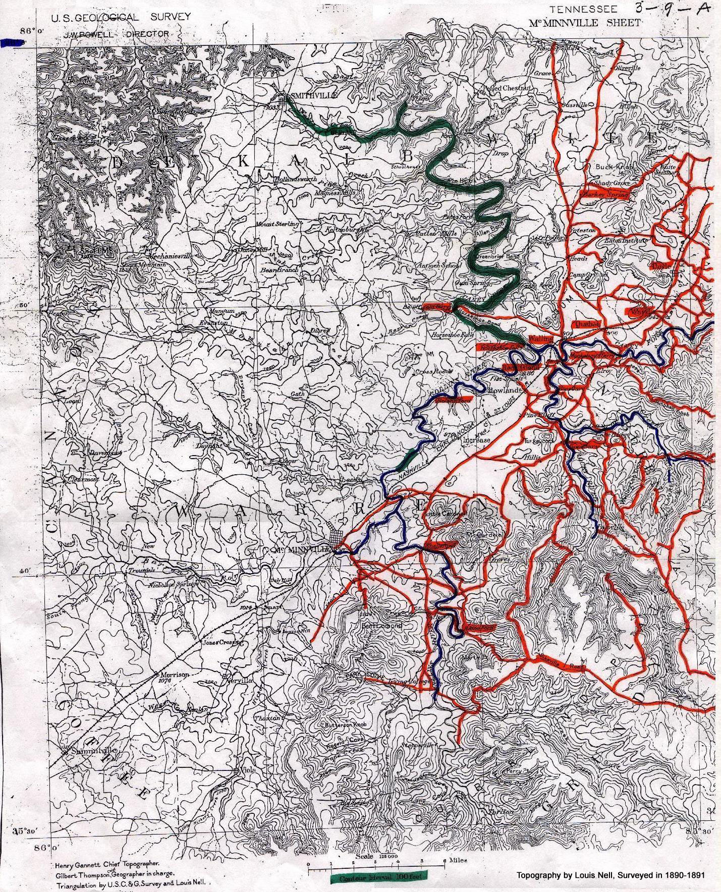
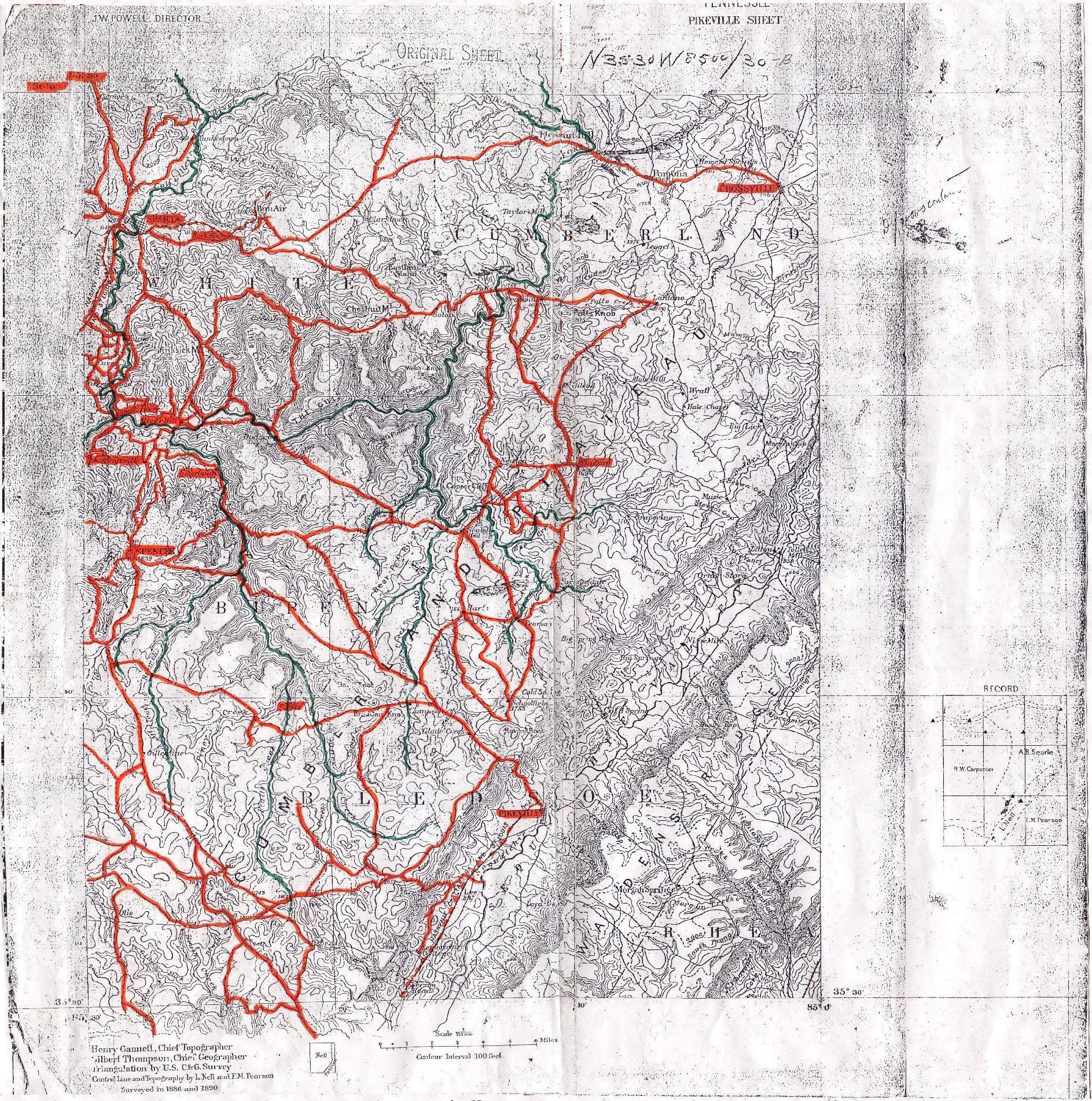
The sheets listed below, all
on a scale of 1/2 inch equals 1 mile are very valuable in
studying the Caney Fork and tributaries. The early
quadrangles, mapped in the 1890's are especially helpful
since they show many of the old roads, fords and ferries
before modern roads were located and built in the area.
They also contain many old place names. The following cover
most of the Caney Fork area:
Gordonsville
Hollow Rock*
McMinnville [download
this map - large image file]
Pikeville [download
this map - large image file]
Sewanee
Standing Stone
Woodbury
*An interesting feature on
this sheet is the large green area shown marked Plateau of
Barrens. |
|
|
The writer has also referred to scrap books covering the
following general subjects: |
|
McMinnville, Warren County,
Tennessee, Rock Island, Caney Fork and many maps and
reports made and notes by Old
Timers written up by the writer. |


