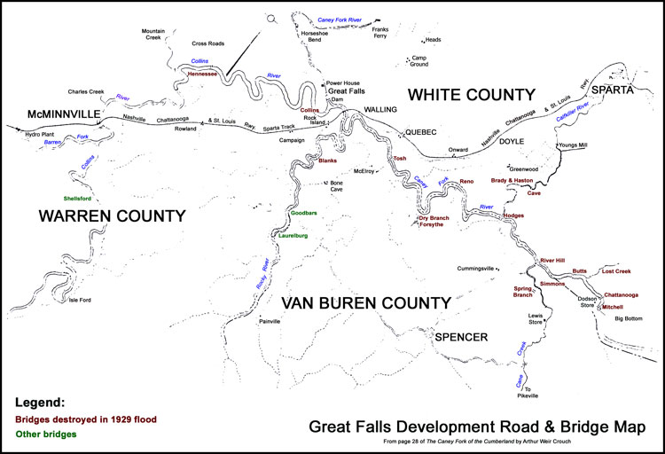
| McMinnville (Hgw. 108 to
Viola) crossing Barren Fork 6.75 miles above the mouth.
|
This also carried traffic to Manchester,
Hgw. 55, for many years. In a deed from John L.
Spurlock to the McMinnville & Manchester Railroad in 1858
there is a reference to "a bridge built by the County."
This probably was a wooden bridge. Later an Iron
bridge was built just below the present Railroad bridge and
the power dam. This was replaced several years ago.
For additional information on this bridge see page 34 of the
book (or go to the
next website page) .
|
| Beersheba Bridge across
Barren Fork 5.8 miles above the mouth on the Beersheba Road.
|
According to John Argo the first bridge
was located at the upper end of the bluff at the lower end
of nursery bottom and below the present bridge. It was
never completed but persons could walk across it. It
apparently was washed out in the flood of 1872 while under
construction. An "iron bridge" built shortly before
1902 was destroyed by the 1902 flood. John Argo said
the new bridge was built by the County after an agreement
was made that others would be built in other parts of the
County. Bridges built at the same time over Hickory
Creek, Lusk Ford (Hgw. 70S) and Hennessee ford were
destroyed in the same flood. Following the flood the
bridges were all replaced. The 1928 flood again washed
out the Beersheba bridge.
|
| Blanks Bridge
crossing Rocky River 2.8 miles above the mouth
was built by |
The Tennessee Electric Power Co.
[T.E.P.Co.] in 1916 when the Rock Island dam was built.
It is located a short distance up stream from the old Blanks
Mill dam. The bridge was raised and lengthened in 1924
when the Rock Island dam was raised.
|
|
Brady-Haston Bridge
crossing the Calfkiller River 3 miles above the mouth and just
|
below a spring branch on which the mill of
the same name was located. The bridge was built by the
County in the early part of the 20th. century and was first
called "Johnson's Bridge" after the owner of the mill at
that time. The bridge was raised in 1924 when the Rock
Island dam was raised. The Brady-Haston bridge served
as a crossing for the wagon road from Hickory Valley to Rock
Island. It is mentioned in an 1862 deed to Joseph W.
Taylor.
Webmaster note: The bridge
was partially named for Carroll Haston, son of Charles
Thomas Haston, son of William Carroll Haston, son of David
Haston, son of Daniel Haston.
|
| Butts Bridge crossing
Caney Fork 19 miles above the Dam. The bridge was built in
|
1924 by the T.E.P.Co. Raising the
dam 35 feet flooded out the Butts and adjacent fords.
The bridge was washed out in the 1929 flood and replaced by
the Power Co.
|
| Cave Foot Bridge
[at
Cave, TN] across Calfkiller River 4.2 miles above the mouth of
the river. |
The suspension bridge was built in 1924 by
the T.E.P.Co. to replace an old bridge at a lower level.
It is located just upstream from the Burroughs & Taylor
Factory. This company made men's work clothes.
|
| Chattanooga Foot Bridge
crossing Caney Fork River 20.9 miles above the Rock Island dam |
is very close to the old Chattanooga Ford.
The suspension bridge was built in 1924 by the T.E.P.Co.
It was washed out in the 1929 flood.
Webmaster note: This
foot bridge ("swinging" or "wire" bridge) was rebuilt after
the 1929 flood and was in use for several years. It
was located behind Fraiser's Chapel Methodist Church.
A Boy Scout camp was located at the site of the bridge and
ford, some time prior to the mid-1950s. In the early
1960s, Wayne Haston and a friend walked across this bridge
carrying hunting guns. The bridge was in a dangerous
state of disrepair at that time. The cables were rusty
and the existing floor planks were rotting and some of the
planks were completely gone. In the 1950s, Dave Guy
(who lived north of the river in "Fox Hollow") was employed,
as needed, to keep the bridge in good repair.
Apparently, no one replaced him on this task when he moved
his family to upper Hickory Valley. By that time, many
of the families in that community had automobiles and could
get from one side of the river to the other by means of
Butts Bridge.
|
| Collins River
Bridge spans the Collins River at its mouth. The first
bridge was a timber |
structure. It was built by Asa
Faulkner in connection with the erection of the Falls City
Cotton Mill. Mr. Faulkner employed James McGiboney to
build and operate a saw mill and grist mill at the Great
Falls before he began work on the Cotton Mill.
McGiboney sawed out all the timbers for the bridge.
This bridge was destroyed in the 1902 flood. The next
bridge was a steel structure erected in connection with the
construction of the first dam and power house for the
Tennessee Power Co. The third bridge was erected
in 1923-24 by the T.E.P.Co. in connection with raising the
dam 35 feet. Perhaps of interest is the fact that the
longest span in the bridge had one time been part of a
bridge across the Cumberland River in Nashville. The
structure was dismantled and stored by the Nashville Bridge
Company.
|
| Dillon Bridge
crossing Caney Fork River about 4 miles above the Dam. This
was one of the |
two earliest bridges on the upper Caney
Fork.
|
The bridge had 3 spans resting on
rock-filled log cribs. Joe Slatton said that 2 of the
piers were visible in 1920 when the reservoir level was very
low. There is a reference to a "valuable bridge" in
White Co. deed bk. O, p. 276-77 in 1846. On pages
166-67 of the same book in 1851 there is a reference to
"ferry and boats." By that time the bridge was
probably out of service. Florence Woods said the last
man to cross the bridge was a peddler name Redder. The
bridge had become "very ramshackle" and it fell as he was
crossing. His horse "Doc" carried him over but Redder
had a nervous breakdown and was laid up for several weeks.
The remains of the bridge were washed out in the flood of
1852. Spence Frank told the writer that the bridge was
very old.
|
| Dam Bridge
- This refers to the bridge built above the Rock Island Dam
in 1915-16 crossing |
Caney Fork. When the Dam was raised
35 feet in 1924-25 the bridge was raised a like amount.
After all preparations had been made, including installation
of new columns a crew of 250 men started from each end,
racing to reach the center of the bridge first for a bonus
of $500 to the winners. The job was finished in 10
hours.
|
|
Double Bridges 17.4 miles above
the Dam. One bridge crossed Caney Fork above the mouth
|
of Cane Creek and the other crossed Cane
Creek at the mouth of the creek. Both bridges were
raised in 1924-25 when the Dam was raised. The bridge
over Caney Fork was washed out in the 1929 flood and not
replaced. The bridges were referred to locally as the
River Hill bridges. The name is that of a small
community that formerly was located on the hill above the
river on the White County side.
Webmaster notes: The
bridge across the mouth of Cane Creek was still in decent
shape as late as the early 1960s, and could be crossed by
automobile at that time, although there was no where to go on
the east side of the bridge except to turn around and go
back across the same bridge. At that time, the road
that went around the east side of Cane Creek (along the
western & southern edges of
Fork Mountain)
had been closed since probably just after the 1929 flood.
|
| Dry Branch Bridge
spans Dry Branch about 1/2 mile from the point where it joins
the Caney |
Fork. It is in Van Buren County.
The steel was moved on barges from the Yost Bridge on Rocky
River. Dry Branch was built by the T.E.P.Co. in 1925.
|
| Forsythe Bridge
spans Forsythe Branch just above the junction with Dry
Branch. It was built |
by the T.E.P.Co. in 1925.
|
| Gillen Bridge
spans Cane Creek 5.1 miles above the mouth of the creek.
It was built |
by Van Buren County sometime prior to
1925.
|
| Goodbar Bridges.
The first bridge was located about 125 feet below the old
Goodbar Mill |
Dam and about 8.9 miles above the mouth of
Rocky River. It was a covered wood bridge according to
Miss Florence Wood. She said it was built by Gumberry
(?) Johnson, was very shaky and in fact it was never really
built right. It burned sometime prior to 1923.
The second bridge, located about 1/4 mile above the Goodbar
Mill. It was built in 1923 or 1924 by the State on
Hgw. 30 from McMinnville to Spencer. It was one of the
first concrete arch bridges built in Tennessee. Truly
it is a beautiful structure.
|
| Gribble Bridge
spans Collins River abut 13.5 miles above the mouth.
It was built by |
Warren County.
|
| Hennessee Bridge
crossing Collins River 8.2 miles above the mouth was one of
four bridges |
built by Warren County about 1900.
All four were washed down in the 1902 flood. Nashville
Bridge Co. salvaged the spans at Hennessee and rebuilt the
bridge. The flood of 1929 again dropped the three
spans into the river. The T.E.P.Co. had the bridge
rebuilt. One new span was purchased and two spans were
salvaged out of the original three. The writer
understands that a new modern bridge was built at this
location in the 1960's and one or more of the old spans were
moved to another location.
|
| Harrison's Ferry
Bridge spans the Collins River in the upper reaches and in
Warren County. |
The County built the bridge. It was
one of the few bridges not damaged in the 1929 flood.
|
| Hash Ford Bridge
on Rocky River. See Yost Bridge. |
| |
| Hodge Bridge
crossing Caney Fork River 13.9 miles above the Dam and a few
hundred feet |
below the mouth of the Calfkiller River.
It is on the Doyle-Spencer Road. The bridge was raised
in 1924 by the T.E.P.Co. It was partially destroyed in
the 1929 flood and rebuilt by the Power Co.
|
| Hgw. 70S at Rock
Island is 1.1 miles above the Dam. This bridge,
crossing the Caney Fork, |
was built in the 1920's by the State.
It is at the location of McClures Ford.
|
| Iron Forge Bridge
across Rocky River just below the old Iron Forge near the
Rowland Ford. |
This is downstream from the present Blanks
Bridge. It was a covered wood bridge. The bridge
broke, according to Mill Florence Woods when Sam _____, a
peddler was crossing with a 6-horse team and a wagon load of
goods. The driver got on the lead horse and went on to
Dillons. He stayed there for several weeks - sick from
the shock. The flood of 1872 washed away the remains
of the bridge.
|
| Johnson's Bridge
on Calfkiller - See Brady-Haston
Bridge. |
| |
| Johnson's Bridge
on Rocky River - See Joab Miller
Bridge. |
| |
|
Joab Miller Bridge across
Rocky River about 1 1/4 miles downstream from the present
|
concrete arch bridge at Goodbars.
Mill Florence Woods told the writer that a saddle belonging
to Belle Miller, sister of Joab, was in the bridge at the
time it washed. She also said that at one time the
stage from Sparta crossed at McElroys (crossed the Caney
Fork River), then followed the road to and crossed the
Miller bridge. It then proceeded on past the Jeff
Gross place and back into the main stage road (Present Hgw.
70S approximately). The stage regularly stopped at
McElroys for dinner.
|
| Laurelburg Bridge
crosses Rocky River 10.2 miles above the mouth. It is a
short distance |
below the old Laurelburg Mill.
|
| Lost Creek Bridge
is a small bridge a short distance above the point where the
creek flows |
into the Caney Fork. It was built in
the latter part of 1925 or early 1926. It took the
place of a ford. When built there was practically no
wagon traffic on the road which really was more of a horse
trail. It was built by the T.E.P.Co.
Webmasters notes:
This creek was also called "Wallace Creek or Branch," or at least it
was in the 1960s.
|
| Lusk Ford Bridge
- See McMinnville Hgw.
70S Bridge across the Collins River. |
| |
| Martin's Ferry
Bridge on the upper Collins River. This is one of the
few bridges that did |
not wash out in the 1902 flood.
|
| Mayberry Bridge
on the Caney Fork - See Rock
Island Bridge. |
| |
| Mitchell Bridge
spans the Caney Fork River 21.2 miles above the Dam. It
was built in 1924 |
by the T.E.P.Co. and was replaced after
being destroyed in the 1929 flood. It was built at the
lower end of Big Bottom. At the time Dodson's Store
stood at the top of the hill above the bridge. Back in
the early 1920's women in Big Bottom made heavy men's socks
from home-spun yarn from local sheep. They traded them
at Dodson's for coffee, sugar, notions, etc. and the
writer bought several pairs at 35 cents a pair. They
were worn with high top boots and never did wear out.
Webmaster's notes:
Local people of the area also referred to this bridge as the
Amos Dodson Bridge, after the man who owned Dodson's Store.
Bonnie V. Dycus was a
water boy for the men who built the Mitchell Bridge.
There was a wire (or swinging) foot bridge at the location
of the Mitchell Bridge, prior to the bridge that was built
by the TN Electric Power Company. Source: Bonnie V.
Dycus, December 26, 2003.
|
|
McMinnville Hgw. 70S
Bridge 19 1/4 miles above the mouth of Collins River.
The first |
bridge across Collins River at this
location was built by the County about 1900. It was
called the Lusk Bridge after the nearby Lusk Ford. It
was damaged in the flood of 1902 and replaced by the County.
When Highway 70S was improved by the State a new and heavier
bridge was constructed in the same general area.
|
| Peter Buram's
Bridge - See Rock Island
Bridge. |
| |
| Rail Road Bridge
crossing Collins River 18.9 miles above the mouth. It is
about 1/3 mile |
downstream from the Hgw. 70S bridge.
It was built several years after the Civil War.
|
| Reno Bridge
spans Caney Fork River 11.3 miles above the Dam. It was
built by the |
Tennessee Power Co. in 1915-16 when the
Dam and Power House were built. It was raised by the
T.E.P.Co. in 1924. This bridge and River Hill*
were the only two on the main river above the Dam that were
not damaged by the 1929 flood. Albert Kuhn, who lived
at the top of the hill on the White County side of the River
kept the drift wood coming down the river from piling up
against the bridge. He worked a good part of the night with
a pike pole.
*Webmaster's note:
The River Hill Bridge that crossed the Caney Fork was
destroyed, but the other bridge at that location that
crossed Cane Creek was not destroyed.
|
| River Hill
Bridges - See Double Bridges. |
| |
|
Rock Island Bridges
crossing Caney Fork River 1.5 miles above the
Dam was originally |
built by the Mayberrys. Starting
from the White County side of the river it crossed to the
Island. There was a gap to allow stopping on the
Island and then it continued across the slough to the Warren
County side. It was a rough wood bridge resting on
rock filled log pens. It was probably built about 1814
or 1815. (This is base on names and dates on land
transfers.) The bridge was damaged in a flood and in
poor condition when Peter Buram rebuilt it around 1826.
One of the older natives said that Buram repaired the bridge
"in a very ungainly manner." People referring to
something that was not straight or poorly constructed would
say, "It's as crooked as Peter Buram's bridge." The
property was sold to General John B. Rodgers, including the
bridge in 1838. The bridge was not kept in good repair
and was badly damaged in the 1852 flood. General
Rodgers cleared the remains from the river, and again put
the ferry in operation.
|
| Shells Ford
Bridge crossed Collins River 24.8 miles above the mouth of
the river. |
It was a short distance downstream for the
Shells Ford Mill. Note - The name is frequently
written "Shellsford."
|
| Simmons Bridge
spans Cane Creek 1.8 miles above the mouth of the creek.
It was built |
by the T.E.P.Co. in 1924.
Webmaster's note:
This bridge was located about 1/2 mile south of the current
location of Haston's Chapel Church of God.
|
| Simpson's Bridge
on Calfkiller River - See Young's
Mill Bridge. |
| |
| Sparta Hgw. 70S
was built across the Calfkiller River 12.1 miles above the
mouth of the |
river and in the town of Sparta.
Goodspeed refers to it in 1887 as being one of "only three
bridges in the County of any size." The original
bridge has been replaced.
|
| Spring Branch
Bridge spans Spring Branch less than a quarter of a mile
above the mouth |
where it joins Cane Creek. It was
built by the T.E.P.Co. in 1924. This bridge and Simmons
Bridge are on the road from Cummingsville to and up Cane
Creek.
Webmaster's note:
Actually, the Simmons Bridge was on the road that
runs from the Cane Creek road north toward Hickory Valley,
but only about 1/2 mile from where the road to/from Hickory
Valley intersects the Cane Creek - Cummingsville Road.
|
| Tosh Bridge
spans the Caney Fork 5.4 miles above the Dam. It is just
below the spring |
and spring-branch where the Tosh Mill was
located. It was built in 1915 by the Tennessee Power
Co. and raised in 1924 by the T.E.P.Co. It was washed
down in the 1929 flood and rebuilt.
|
|
Yost Bridge was built across Rocky
River 0.7 miles above the mouth of the river in 1915.
|
It was at the site of the Hash Ford.
It was named after Fielding Yost, the great football coach
and Director of Athletics at Michigan. He was one of
the three men who really were responsible for the start of
the Great Falls Development. The bridge was built by
the Tennessee Power Co. On January 1, 1925, a clear
cold morning, 2 barges were pushed up the river, anchored
under the bridge and the steel work was lowered on to the
barges. They were pushed down Rocky River and up the
Caney Fork to Dry Branch. The steel was used in the
Dry Branch and Forsythe Branch bridges.
|
|
Youngs Mill Bridge was
built across Calfkiller River 6.0 miles above the mouth of the
river. |
The bridge was first called Simpson's
Bridge after the man who had it built and owned the mill at
the time. According to J. A. (Jim) Baker of Campaign
it was a wood bridge supported on wood poles and was about
rotted out in 1912. Jim actually saw it in 1912 when
he was working with the survey party on the first survey for
the Great Falls or Rock Island power project. The
first bridge was replaced with a steel structure - probably
about 1915.
Webmaster's note:
This bridge was also known by local people as the County
House Bridge, due to the fact that it was very near the
White County "County House" (Poor House).
|
|
Bridge Notes
Goodspeed's History of
Tennessee, 1887 states that there were only three bridges of
any size in White County and lists Simpson Mill, Sparta and
Gillens Mill bridges. It further states that there were no
bridges of any size in Warren County. The county histories
were written by different men and their ideas of size might have
been different.
Foot bridges across small streams
were sometimes built by felling a tree and dropping it across
the stream. |